
Subsurface Expressions of the Aravalli-Delhi Fold Belt in the Western Ganga Basin by Magnetotellurics
Authors
-
CSIR-National Geophysical Research Institute, Uppal Road, Hyderabad - 500 007
 Ajay Manglik
 -
CSIR-National Geophysical Research Institute, Uppal Road, Hyderabad - 500 007
M. Suresh
-
CSIR-National Geophysical Research Institute, Uppal Road, Hyderabad - 500 007
Danda Nagarjuna
-
CSIR-National Geophysical Research Institute, Uppal Road, Hyderabad - 500 007
G. Pavankumar
-
CSIR-National Geophysical Research Institute, Uppal Road, Hyderabad - 500 007
M. Demudu Babu
-
CSIR-National Geophysical Research Institute, Uppal Road, Hyderabad - 500 007
N. N. Chakravarthi
-
CSIR-National Geophysical Research Institute, Uppal Road, Hyderabad - 500 007
Raj Sunil Kandregula
DOI:
https://doi.org/10.1007/s12594-022-2242-4Keywords:
No KeywordsAbstract
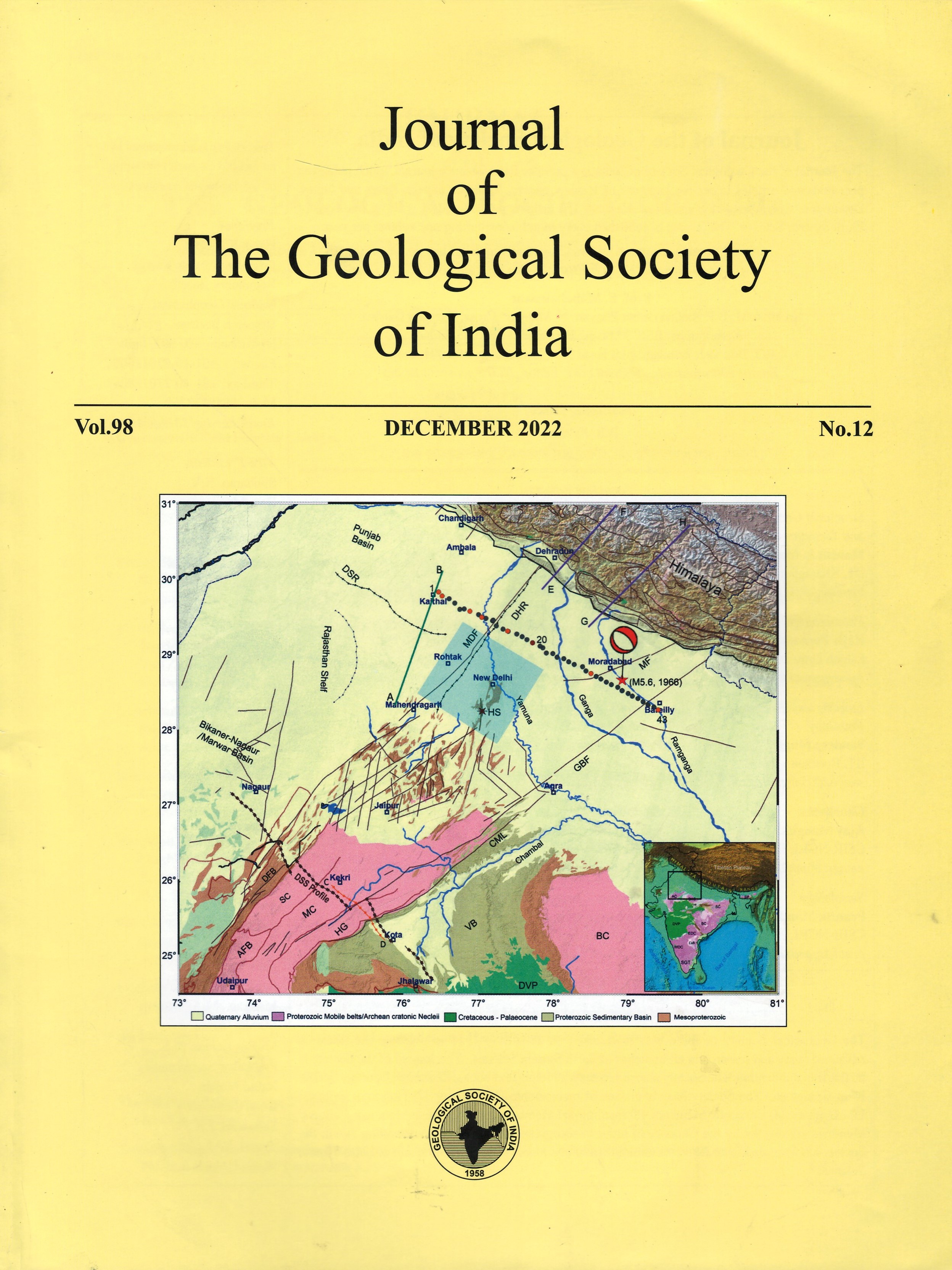
The Aravalli-Delhi fold belt (ADFB) in the NW Indian shield is associated with moderate level of seismicity, including the seismicity of the Delhi seismic zone (DSZ). Several studies have postulated northward extension of the ADFB beneath the alluvium cover of the Ganga basin and its existence beneath the Himalaya. However, subsurface disposition of the ADFB north of Delhi has not been mapped in detail. The results of a recent magnetotelluric study carried out along a profile between Kaithal and Bareilly across the inferred northward extension of the ADFB is presented to address this issue. The results reveal that the concealed ADFB consists of a collage of nearly vertical conductive and resistive blocks buried beneath about 1 to 1.3 km thick alluvial sediments. The boundaries of major inferred tectonic features, such as the western boundary of the Delhi-Haridwar ridge (DHR) and the Great Boundary Fault (GBF), as well as the locations of the Ganga and the Yamuna rivers coincide with such steep contacts. The results suggest the presence of some more concealed geological contacts/tectonic boundaries for which no corresponding surface tectonic features have been mapped. Such a configuration of nearly vertical conductive and resistive blocks has significant implications for the studies aimed at earthquake hazard assessment of the region, especially the DSZ. These results, in conjunction with the MT models available for the Garhwal Himalaya, also indicate continuation of these blocks beneath the Kumaun-Garhwal Himalaya (KGH). Thus, the crust of the KGH below the Main Himalayan Thrust should be highly heterogeneous spatially.

Downloads
Metrics
Issue
Section
Published
How to Cite


