

Volume 100, Issue 2, February 2024 Pages (153-304)
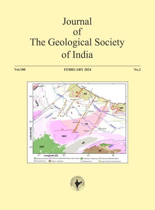
Map showing general geology and tectonic features of the Ganga basin and adjoining regions, including the buried Faizabad Ridge as a NE-to-NNE extension of the Bundelkhand craton (Sastri et al., 1971; Rao, 1973). Major geological and structural features as well as basement depth contours shown in this figure are taken from the shape files available at the BHUKOSH portal of Geological Survey of India (http://bhukosh.gsi.gov.in/Bhukosh/MapViewer.aspx). Basement depth contours are derived from the aeromagnetic data (Agocs, 1957). Orange circles are the MT sites along the four profiles. Abbreviations are: ADFB – Aravalli Delhi Fold Belt, BKC – Bundelkhand Craton, BTZ - Bundelkhand Tectonic Zone, DHR – Delhi-Haridwar ridge, DVP – Deccan Volcanic Province, FR - Faizabad Ridge, GBF - Great Boundary Fault, GD – Gandak Depression, LF – Lucknow Fault, MDF – Mahendragarh-Dehradun fault, MF – Moradabad fault, SC – Singhbhum craton, SD – Sharda Depression, VB – Vindhyan Basin. For details see pages 181-188
Published:
2024-02-01
Editorial
-
The Journal Geological Society of India: Its Journey to 100th Volume, Challenges and Way Forward
 G. M. Bhat155-158
 Abstract views: 64 times|
 Download: 58 times
Review Article
-
Recent Studies on Volcanic Materials and Chemistry of the Earth’s Interior – An Indian Perspective
N. V. Chalapathi Rao, G. Parthasarathy159-167- Requires Subscription PDF
Abstract views: 31 times|
Download: 5 times
Research Articles
-
Landslide Susceptibility and Risk Mapping in the Tectonic Ensemble Comprising of Eastern Himalayan Zone, Northeast India and Bhutan Using Logistic Regression and Random Forest Techniques
Arnab Sengupta, Sankar Kumar Nath168-180- Requires Subscription PDF
Abstract views: 18 times|
Download: 2 times
-
Northern Limit of the Concealed Bundelkhand Craton: A Synthesis of New Magnetotelluric Results from the Ganga Basin
Ajay Manglik, G. Pavankumar, M. Suresh, N. N. Chakravarthi, M. Demudu Babu181-188- Requires Subscription PDF
Abstract views: 10 times|
Download: 5 times
-
Geomechanical Characterization of the Barren Measure Formation in the Raniganj Sub-basin of Damodar Basin, India
Waquar Ahmed, John McLennan, G. M. Bhat, Sudeep Kanungo, Bryony Richards, Thang Tran, Bindra Thusu, Naveen Hakhoo, Mateen Hafiz189-202- Requires Subscription PDF
Abstract views: 70 times|
Download: 2 times
-
Magmatic and Geochemical Studies of Early Neoproterozoic Koraput Anorthosite Massif, Eastern Ghats Mobile Belt and their Implications for Rodinia Assembly
Dicton Saikia, Pritam Nasipuri203-217- Requires Subscription PDF
- Requires Subscription Supplementary File
Abstract views: 72 times|
Download: 1 times
-
Pillow Morphology of Bathani Volcano-sedimentary Sequence of Eastern Indian Shield: Inferences on the Geotectonic and Geo-Environments
Mansoor Ahmad, Abdul Qayoom Paul, A. Saikia218-232- Requires Subscription PDF
- Requires Subscription Supplementary File
Abstract views: 71 times|
Download: 1 times
-
The Ancient Metal Miners of Vadnagar, Delwara and Mandli, Western India
A. K. Grover233-240- Requires Subscription PDF
Abstract views: 6 times|
Download: 1 times
-
Carbonate-hosted U-deposit in the Tummalapalle Area, Andhra Pradesh, India: A Potential Source to Generate Critical Minerals of REs, V, Mo, Co, Ni, Cu, Ag and Phosphate as Value-added By-products
R. Dhana Raju241-249- Requires Subscription PDF
Abstract views: 37 times|
Download: 4 times
-
Discovery of Stenothyrid Gastropod from Deccan Intertrappean at Barga Village, Madhya Pradesh and its Palaeoenvironmental Significance
Sharmistha Paul, Tapas K. Gangopadhyay, Arif M. Sikder250-256- Requires Subscription PDF
Abstract views: 60 times|
Download: 3 times
-
Geoelectrical and Remote Sensing in the Characterization of the Pan-African Meta-sedimentary Basement Aquifer Systems: A Case Study at Nkoteng-Elap, Central Region of Cameroon
Ferdinand Deffo, Lionel Mbida Yem, Joseph Quentin Yene Atangana, Serge Parfait Koah Na, Yannick Saturnin Evina Aboula, Jean Marc Medza Ekodo, Renaud Menanga Tokouet, Ingrid Armel Madjougang Beukam257-267- Requires Subscription PDF
- Requires Subscription Supplementary File
Abstract views: 6 times|
Download: 1 times
-
Construct a Geomechanical Model to Estimate the Critical Drawdown Pressure for the Sandstone Reservoirs
Mustafa Adil Issa, Muntadher Adil Issa, Ali Nooruldeen Abdulkareem, Ali A. Al-Zuobaidi, Farqad Ali Hadi268-276- Requires Subscription PDF
Abstract views: 7 times|
Download: 2 times
-
Investigating and Measuring Radon Gas Concentration in Tehran and Alborz Metro Stations
Fakhraldin Yavarian, Jamshid Soltani, Abdollah Khorshidi277-286- Requires Subscription PDF
Abstract views: 6 times|
Download: 1 times
-
Simulation of Rock-Water Interaction in the Southwestern Part of El Minya Governorate of Egypt
Ahmed A. Asmoay, Ibrahim E. Mousa, Walid A. Mabrouk287-296- Requires Subscription PDF
Abstract views: 6 times|
Download: 1 times
News and Notes
-
Hindustan Gold Private Limited Ventures into Advanced Gold Processing with Plans to Introduce POX Technology in India
V. N. Vasudev299-299 Abstract views: 88 times|
Download: 8 times
-
National Seminar on "Sustainable Steel Making in India: The Way Forward" by SGAT on 9 September 2023 at SGAT Auditorium, Bhubaneswar
B. M. Faruque, J. N. Das300-301 Abstract views: 72 times|
Download: 22 times
Obituary
-
Prof. Dilip Saha (1955-2023)
Tridib Kumar Mondal, Colleagues at ISI Kolkata302-302 Abstract views: 80 times|
Download: 23 times
Errata
-
Miocene Stromboid Gastropods (Superfamily Stromboidea Rafinesque, 1815) from the Dwarka Basin, Western India and their Paleobiogeographic Implications
Kanishka Bose, Shiladri S. Das, Sandip Saha303-303 Abstract views: 113 times|
Download: 27 times

