
Conference Papers
Neoproterozoic Chert Permineralized Silicified Microbiota from the Carbonate Facies of Raipur Group, Chhattisgarh Basin, India: Their Biostratigraphic Significance
SKU:
C-63321
A diverse assemblage of microorganisms are being discovered in black bedded, nodular and lenticular silicified cherts in the limestone/dolomite sequence of the Saradih Formation, Raipur Group, Baradwar sub-basin - a part of main Chhattisgarh basin, India. The composition of microbiota in the present assemblage includes 33 genera (9 acritarchs and 24 cyanobacteria) of different morphotypes categorized as: Acritarchs - Comasphaeridium, Dictyotidium, Favososphaeridium, Leiosphaeridia, Meghystrichosphaeridium, Navifusa, Tianzhushania, Trachyhystrichosphaera and Trachysphaeridium; Coccoids - Eoentophysalis, Eomicrocystis, Eosynechococcus, Glenobotrydion, Gloeodiniopsis, Myxococcoides, Palaeoanacystis, Scissilisphaera, Sphaerophycus and Tasmanites; Filaments - Archaeotrichion, Biocatenoides, Cephalophytarion, Cyanonema, Eomicrocoleus, Heliconema, Oscillatoriopsis, Palaeolyngbya, Partitiofilum, Polybessurus, Polythrichoides, Siphonophycus, Richnonema, and Veteronostocale. Like equivalent Proterozoic microbiota, the Saradih assemblage includes extensively well preserved morphotypes of both prokaryotic and eukaryotic affinities representing planktic and benthic habitats belonging to different groups and families. The mat forming and mat dwelling forms are abundant in Saradih assemblage. Mat-dwelling microbenthos and possible coastal microplanktons are abundant in subtidal to lower intertidal settings whereas, densely woven mat populations with few associated taxa characterized more restricted parts of tidal flats. The preservation of vertically oriented sheaths and bundles indicates that in these mats carbonate cementation was commonly penecontemporaneous with mat growth. The microbiotic population in present finding are widely recorded from the peritidal to open shelf carbonate facies of the Late Neoproterozoic (Cryogenian) sediments across world.
Origin, Depositional Setting and Stratigraphic Implications of Palaeogene Glauconite of Kutch
SKU:
C-105413
A combined sedimentological, stratigraphical, mineralogical and geochemical investigation on Palaeogene glauconites of Kutch address some of the crucial issues related to origin of glauconite and its depositional and stratigraphic significance. Glauconite occurs within fossiliferous green shale units of Naredi, Harudi and Maniyara Fort Formation. It occurs primarily in two modes, either as an altered form of fecal pellets or as infillings within the bioclasts. The origin of glauconite may be best explained by direct precipitation of Fe-rich glauconitic smectite within the pores of bioclasts and fecal pellets followed by its maturation to glauconitic mica by the addition of K. Fecal pellet is a more favourable substrate than bioclasts for glauconitization because of easy percolation of pore water within and availability of relevant ions in pellets. Strong biostratigraphic control allows us to clearly establish that relatively high rate of sedimentation (>27 m/Ma) discourage glauconite formation in the Fulra limestone while low rate of sedimentation rate (<5m /Ma) allowed its formation. Occurrence of glauconite exclusively within the transgressive systems tracts and its absence within the highstand systems tracts corroborates the requirement of low rate of sedimentation. Formation of mature glauconite in shallow marine open as well as in protected lagoon suggests that glauconite may be a poor indicator of depositional environment, despite the fact that it forms in modern deep marine conditions. However, positive Ce-anomaly in all glauconites suggests that dys-oxic depositional setting encourages glauconite formation. Absence of glauconite within the unfossiliferous and emerged red shales, immediately overlying and underlying the glauconitic green shales suggest that oxic condition discourages glauconite formation.
Palaeocene to Early Eocene Planktonic Foraminifera of the Pondicherry Area, South India
SKU:
C-63308
Planktonic foraminifera from several outcrops and sections in the Pondicherry area, South India, were analyzed to determine their age. Preliminary analysis of the samples collected from various outcrops and sections of Pondicherry area yielded abundant well preserved planktonic foraminifera belonging to Globoanomolina, Parasubbotina, Subbotina Praemurica, Igorina, Acarinina, Morozovella, Pseudohastigerina and Astrorotalia occurring in part of the sequence in association with abundant Discocyclinids. Fifty-two planktonic foraminiferal species of these genera are recorded from and interval spanning from the early Palaeocene zone P1b to the early Eocene zone P9. The stratigraphic distribution of the planktonic foraminifera from these samples do not allow identification of individual biozones, undifferentiated zone intervals can be recognized, including P1b-P2, P3a-P5 and P6-P9. Species are illustrated based on SEM microphotographs. More detailed biostratigraphic work is needed and will be carried out to identify individual zones and determine the completeness of the sections.
Palaeoecology and Affinity of Ostracod Fauna from the Classic Localities of Lameta Formation of Jabalpur, Madhya Pradesh, India
SKU:
C-63313
Contrasting opinions have been expressed by different workers about the palaeo-environments of the Lameta Formation of Jabalpur. Some workers have ascribed a shallow marine/estuarine environment of depositions for its sediments, while others have favoured a non-marine interpretation. The present authors have recently recorded 26 ostracod species from the basal beds of Lameta Formation from three classic localities (i.e., Chui Hill, Bara Simla Hill and Chhota Simla Hill). These are univocally freshwater fauna. Khosla and Sahni (2000) earlier proposed Late Cretaceous Mongolian and Chinese affinities for the ostracod fauna of the Lameta Formation of Jabalpur. Whatley and Bajpai (2006) considered them strongly endemic to India. Our study revealed an African and/or South American zoogeographic affinity. The genera common to these continents are Altanicypris, Neuquenocypris, Paracypretta, Stenocypris and Wolburgiopsis.
Palaeoenvironmental Significance of Rectilinear Benthic Foraminifera in the Middle Eocene Section of Matanomadh Sub-Basin, Kutch
SKU:
C-63306
A lignite-bearing section at Matanomadh (N23?30'; E68?55') in Kutch was examined for its foraminiferal assemblage. The section consists of lignite and carbonaceous shale in the lower part and mudstone in the upper part. The mudstone is characterized by a low diversity and moderate abundance of dwarf foraminifera. The presence of Halkyardia minima, Linderina kutchensis and Lockhartia alveolata suggests its correlation with Fulra Limestone exposed in the adjoining regions of Kutch. The smaller benthic foraminifera mainly include the species of Brizalina, Bulimina, Trifarina, Cibicides, Discorbis and Guttulina. The Rectilinear Benthic Foraminifera morphogroup (RBF) constituting up to 60% of the foraminiferal assemblage are characterized by large pores. These are typical characteristics of foraminiferal assemblages from low oxygen environment. The peak abundance of RBF occurs consistently at co-eval levels in several sections of Kutch. It is suggestive of dysoxic conditions in late Middle Eocene, corresponding to planktonic foraminiferal zone P13.
Paleoclimate and Paleoenvironment of the Naredi Formation (Early Eocene), Kutch, Gujarat, India
SKU:
C-63302
The Naredi Formation of Kutch, Gujarat, India, is early Eocene in age and marks the first marine transgression above the last Deccan traps. Sediment deposition occurred in a shallow inner shelf environment that varied from a brackish lagoon to brackish, normal inner shelf and to marginal marine environments. The section can be divided into 2 main transgressive cycles interrupted by a regression phase that is marked by a well-defined sequence boundary marked by a root-bearing paleosoil. Three intervals yielded common to abundant benthic foraminiferal assemblages. Planktic foraminifera are few to rare and restricted to the top of the section, except for Chiloguembelina trinitatensis. An early Eocene age can be attributed to the Naredi section based primarily on larger benthic foraminifera (SBZ8 to SBZ11, equivalent to planktic foraminiferal biozones E4 to E6), rare planktic foraminifera, the stable isotope curve and its correlation with marine sections and sequence stratigraphy. Sediments of the transgression/regression cycles were derived from physical and chemical-weathering processes of basaltic rocks as indicated by the different geochemical proxies. Carbon isotope analyses of bivalve shells and organic matter reveal a negative excursion that is correlative with the global Early Eocene excursion. The presence of fish bones, fish teeth and organic matter can be related to the Early Eocene climatic optimum. Clay mineral data from the Naredi Formation indicate variably hot humid to arid climate conditions.

Planning and Management of Water Resources in North East India
SKU:
C-165860
The topographical and geographical locations of North-Eastern region of India, consisting of eight states is unique with the hydro- meteorological situations making it one of the highest rainfall zones of the world. The region is characterized by low population density, difficult topography, different habitation pattern and social culture, rich forestry and biodiversity with changing climatic conditions . Rainfall of the region being high, varies with space and time in the scale 1000-11000mm. The major river basins of the region are Brahmaputra basin, Barak basin, Gumti basin and Imphal basin. Thus, the variability in rainfall causes some parts of the region water deficient affecting the people?s lives in general and agriculture in particular. Whereas the excess rainfall in some other regions, especially in the Brahmaputra valley causes the floods ,drainage congestion, sedimentation and soil erosion problems. The region accounts for about 35% of total water resources of the country though its geographical area (26.23 Mha) is only 8% of the country. Ultimate Irrigation Potential (UIP) of the region is 43.16 Mha. Irrigation Potential Created (IPC) through major, medium and minor irrigation schemes of NE are less than one fifth of UIP. Percentage of net irrigated area (NIA) over net sown area of the region is 18.89 as compared to the national average of 44.88 %. Hydropower potential of this region is 63257 MW, of which only 1911 MW has been harnessed so far (3.02%). Per capita availability of water in the region is highest in the country. However, its harnessing is very limited, which is even less than 5% of the existing potential. In spite of such huge water resources potential of the region, harnessing and development of the water resources potential for irrigation and hydropower is very nominal. Thus, to assist the optimal and sustainable use of water resources in the North Eastern Region, there is a need to plan effectively by applying the management tools, and through institutional collaborations, and accordingly initiate actions for control, conservation and utilization of water throughout the region. This paper is a review on the status of development of water resources in NER. Some views and suggestions are also presented in terms of proper planning and management of water resources in the region.
Plant-Microbe-Rock Association in Exploration for Gold
SKU:
C-165476
The paper presents a detailed record of certain types of lichens, microbes and Spinifex grass that have colonized Banded Magnetite Quartzite outcrops exposed over a 60 km long NNW-trending tract within Peninsular Gneiss in parts of Mandya, Ramanagara and Tumkur districts, Karnataka. The study discusses hyper-accumulation of noble metals and trace elements in Spinifex grass. The most common lichens identified are crustose and foliose that produce organic acids. The rhizosphere zone of the soil immediately around the Spinifex root is a hotspot for microbes. They produce the most complex chelating agents that are capable of removing metallic cations from minerals. The bacterial species Bacillus cereus which releases gold is isolated and identified by using biochemical methods. The Spinifex grass finally accumulates gold in its leaves, from the substratum. In this study, assay of ash of the Spinifex grass has indicated presence of gold and PGE and other metals. A few magnetite ore samples that possibly are source of gold have been analysed by destructive and non-destructive analytical methods. The analyses results have indicated their presence in significant quantity. The reasons why the Spinifex grass accumulates gold, Platinum Group Metals and other metals are presented. This work is still in its infancy and warrants a detailed study.
Plausible Offshore Freshwater Aquifer System off the Kerala Coast: A Case Study from the Kuttanad Area of Kerala
SKU:
C-165443
Offshore freshwater aquifer systems exist in many parts of the globe as seaward extension of coastal aquifers. The coastal aquifer systems are often very heterogeneous, combining numerous high permeability aquifers interlaid with low permeability aquitards with varying total thickness.This heterogeneity plays a major role in the fresh groundwater storage, movement, and groundwater salinity distribution within such systems. The Kuttanad is a low lying coastal tract in the western coast of Kerala underlain mainly by the Recent alluvium and thick Tertiary sediments unconformably resting over the Archaeancrystallines.The isopach maps of stratigraphic formations indicate offshore extension of the aquifer systems. The hydraulic gradient and its response to groundwater draft over the decade in these confined aquifers indicate offshore freshwaterseawater interface.The marine transgressions and regressions in the Pleistocene period influenced the evolutionary history of groundwater in the aquifer systems in this sedimentary formation. Offshore groundwater resources could act as an important additional freshwater resource in times of rising water stress.
Pre-Deccan and Deccan Magmatism in Kutch, India: Implications of New 40Ar/39Ar Ages of Intrusions
SKU:
C-105422
The Deccan Traps are of global interest for their possible links to Cretaceous-Tertiary (K-T) mass extinction event and global climate change. Radiometric dating of Deccan Trap lavas and intrusions have shown that bulk of the magmatic activities occurred 65 (?1) Ma. Isotopic similarity between Deccan and Reunion lavas have been used as an evidence to suggest that Deccan magmas were supplied by the Deccan-Reunion plume-head. Kutch is located in northwest India where, based on the trajectory that Indian plate took while crossing over the Deccan-Reunion plume, the earliest Deccan lavas would be expected to erupt. Contrary to this expectation, published 40Ar/39Ar dates of igneous activities suggested that Kutch volcanics are as old as the rest of the Deccan province, even with a small "tail" eruption occurring as late as ca. 61 Ma.Kutch's geology is complicated by the fact that it is marked by old rifting events and significant neotectonic activities. Here we present four new 40Ar/39Ar ages of igneous intrusions from Kutch. Three such intrusions occur in the so-called 'Island Belt' that juts out of the great salt flats (Great Rann of Kutch) in northern Kutch. The fourth intrusion is a gabbroic body that occurs at Dhar Dongar in southern Kutch. Two of the Island Belt intrusions (Sadara Sill and Nir Wandh gabbro) give ages of ca. 75 Ma. A lamprophyre dike from the Island Belt gave an age of ca. 67 Ma. The fourth intrusion from Kutch Mainland yielded the youngest age found in Kutch of ca. 61 Ma. These ages, combined with those determined in previous studies (65-67?1 Ma), suggest the following: Earliest rift-related magmatism occurred 75 Ma, and is clearly of pre-Deccan age. The rest of the igneous activities occurred in two episodes - the most voluminous episode coincided with Deccan age (65-67 Ma) whereas a small volume igneous activity took place at ca. 61 Ma, following a 6 m.y. long hiatus. The 61 Ma episode appears to occur in many different locations within the Deccan. We suggest that the 75 Ma pre-Deccan rifting-magmatic event is a relict of magmatism that occurred during separation of Madagascar from India, which was caused by the Marion plume.
Precepts for Groundwater Drought Index in Kerala: A Case Study from Chaliyar River Basin
SKU:
C-165452
Groundwater Drought Index (GWDI) is recognized as one of the key Hydrological Indices of drought. But the evolution of drought from meteorological to hydrologic drought is not instantaneous and is dominated by several physical mechanisms. In Kerala due to heterogeneity of terrain, the occurrences of drought at different temporal and spatial scales do not fit into the broad indices of standard GWDI. Hence drought prediction has become a major challenge to decision and policy makers as it fails to address multiple causative factors to recognize the actual ground realities. This paper is an effort to bring out the meteorological, hydrogeological and hydrological factors based on which an attempt has been made to review the groundwater drought index to suggest an improved groundwater deficit class by studying the extreme climate eventualities during 2016 (drought) and 2018 (flood). The progression of drought and its corresponding effect on groundwater regime in Chaliyar river basin has been studied in detail. Based on the typical response of drought conditions in different physiographic zones, a modified GWDI from the case study is proposed.
Predictive Modeling and Groundwater Impact Assessment for a Highway Engineering Project in Vizhinjam, Kerala
SKU:
C-165453
Groundwater Impact Assessment is an evaluation of foreseeable impacts on groundwater system, both beneficial and adverse. It is intended to help reveal mitigating measures and alternative solutions to optimize positive impacts while reducing or limiting negative impacts. In highway construction projects a consistent transportation network, through environmentally balanced development is possible only through a detailed knowledge of geology, natural resources and analysis of the land use pattern with precise database. The derogation of water sources for the creation of barriers and pathways for groundwater flow formed by foundations or ground improvement processes for highway construction in a sub watershed of Karamana river basin near Vizhinjam International Sea port area is envisaged in the present study. The study is addressed to generate a database for planning and design process based on the societal concern related to the groundwater impact of post road construction scenario. The modeling for the management of urban hydrology is based on the surface runoff, the rate of rainfall, aquifer characteristics, hydro-geological and geotechnical observations, the type of receiving environment and the applicable criteria for the receiving water course. The spatial analysis of the data generated through field survey, shows draining nature of shallow groundwater zones as indicated by 81 non-perennial wells and farm ponds within the watershed. Geotechnical and geophysical survey shows the presence of a major stratum of laterite with clayey soil at the top and weathered rock at places at the bottom in the core sections. Modeling of the groundwater flow of the region through MODFLOW shows a lesser recharge and a lesser vertical flow compared to evapotranspiration and the hydraulic conductivity respectively. Thus an action plan is proposed to be developed for the construction of link road by reviewing the existing practice of water resource utilization and also by assessing the environmental impact to the groundwater regime to improve the existing groundwater availability of region by constructing subsurface dykes, recharge ponds, elevated road above the existing ponds etc. The study was thus aimed to suggest remedial measures to nullify the impact on the groundwater ecosystem, and also to improve the present status of groundwater availability through predictive modeling.


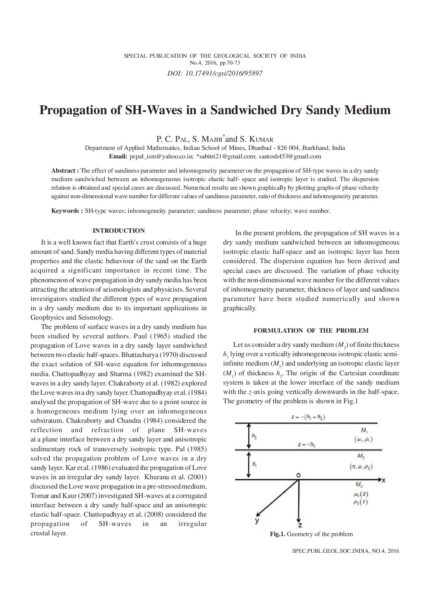
Propagation of SH-Waves in a Sandwiched Dry Sandy Medium
SKU:
C-95897
The effect of sandiness parameter and inhomogeneity parameter on the propagation of SH-type waves in a dry sandy medium sandwiched between an inhomogeneous isotropic elastic half- space and isotropic layer is studied. The dispersion relation is obtained and special cases are discussed. Numerical results are shown graphically by plotting graphs of phase velocity against non-dimensional wave number for different values of sandiness parameter, ratio of thickness and inhomogeneity parameter.
Quality Assessment of Ground Water in Coastal Maharashtra with Special Reference to Sea Water Intrusion
Conference Papers, SP-12: Water Resources of Western and Central Regions of India: Status, Issues and Strategies
SKU:
C-168754
Palghar, Thane, Raigad, Ratnagiri, Sindhudurg and Greater Mumbai districts of Maharashtra form the Konkan Coastal belt of Maharashtra. In the coastal areas the immediate effect of high groundwater development is often sea water intrusion. Although there were sporadic studies by earlier workers (Umrikar et al., 2007, Gupta et al. 2010) into some reported isolated cases of seawater intrusion in the coastal areas, this has been a maiden attempt to decipher the extent of seawater intrusion in the entire coastal tract of Maharashtra.The area is underlain by Dharwarian meta-sediments (Lower Precambrian age), Deccan Trap lava flows (Upper Cretaceous to Lower Eocene age), Laterites (Pleistocene age) and Coastal alluvial deposits (Recent to Sub-Recent age). Groundwater occurs under phreatic condition in the Coastal and riverine alluvium, laterites and weathered/fractured rocks. The area has been covered by systematic hydrogeological surveys, reappraisal Surveys and groundwater monitoring by CGWB. in these formations depth to water levels range from 0.6 m bgl to 8.07 m bgl. Groundwater is mildly alkaline with pH range of 6.9 to 9.0. Electrical conductivity ranges from 61 to 29370 ?S/cm at 25?C. Only two Samples from Dapoli in Raigad district show EC values higher than 3000 ?S/cm at 25?C. In general, water quality is good and suitable for domestic use and irrigation. In order to confirm the sea water intrusion, ionic ratios like Na:Cl, and Cl:CO3 + HCO3, were computed. From the analysis it is found that about 2 to 10 km wide coastal belt and the inland tidal backwaters are affected by salinity intrusion. It is revealed that about 55% of the analysed samples have indicated salinity ingress. The extent of sea water intrusion is more in the southern part progressively diminishing towards northern area. The maximum effect is observed in Sindhudurg district followed by Ratnagiri, Raigad, Palghar and Greater Mumbai.Over-exploitation of groundwater in pockets and diminishing seaward freshwater flow in the rivers are the major reasons for sea water ingression. Regulation of groundwater development in the coastal area and areas adjacent to estuaries, maintaining adequate stream flow, stopping of riverbed sand mining, construction of tidal regulators at suitable places and creation of fresh water barrier through rainwater harvesting and groundwater recharge are essential to control further sea water intrusion in the area.
Quality Control Practices in Gold Exploration in India: Comparison with the Global Benchmarks
SKU:
C-165472
The prominent mining jurisdictions such as Australia, Canada, South Africa and a number of other countries have their own reporting standards which are subject to evaluation and refinement from time to time under the aegis of the Committee for Mineral Reserves International Reporting Standards (CRIRSCO). India adopted the United Nations Framework Classification (UNFC) for National Mineral Inventory (NMI) in the year 2000 and extended the use of UNFC for statutory reporting of results of exploration through legislation in 2003.The main objective of the UNFC is to create a National Inventory of Mineral Resources. There are many challenges in applying UNFC as a reporting standard in a country like India where no reporting standards existed till the adaption of UNFC. This paper makes an attempt to evaluate the suitability of UNFC as a reporting standard in the Indian context using the data presented in the exploration reports uploaded by the Indian government agencies for precious metal exploration programs.It has been observed that the reports prepared by the government agencies do not describe in sufficient detail the quality control measures adopted while executing the exploration programs. For example, the details on the procedures adopted in core orientation, borehole deviation surveys, core photography, sampling, sample preparation, assaying and QAQC are often not described in detail. In the absence of a provision for independent auditing of the procedures by a Competent Person in UNFC, the reports prepared by Indian exploration agencies will not be able to create adequate confidence among the investors on the quality of the work carried out. It is necessary to adopt the global best practices at all stages of exploration to ensure transparency, materiality and competence in the system, especially in the exploration programs for non-bulk commodities. An exploration program conducted using the CRIRSCO compliant procedures can be slotted in an appropriate UNFC class for the National Mineral Inventory purpose.
Reflection and Transmission of SH-Waves through a Self-Reinforced Elastic Layer Embedded Between Two Transversely Isotropic Inhomogeneous Elastic Half-Spaces
SKU:
C-95896
The reflection and transmission of plane SH-waves through a self-reinforced elastic layer sandwiched between two transversely isotropic inhomogeneous elastic half-spaces is studied. The expressions for reflection and transmission coefficients are obtained. These coefficients are plotted against the wave number. It is found that the reflection and transmission coefficients are influenced by the reinforcement parameters of the sandwiched layer. The results obtained are presented graphically. Some special cases are also considered.
Regional and Deposit Scale Controls of Gold Mineralization in Chitradurga Schist Belt, Dharwar Craton, India
SKU:
C-165462
All the known lode gold prospects and deposits in Chitradurga schist belt (CSB) are spatially associated with two transcrustal shear zones, Chitradurga Eastern Shear Zone (CESZ) and Chitradurga Central Shear Zone (CCSZ), though they have varied geological setting with regards to lithology and host structure. Along its entire stretch, the CCSZ is characterized by a wide zone of intense carbonatisation, however no such regionally extensive carbonatisation is associated with CESZ. Auriferous quartz carbonate lodes are localized along zones of dialatation like second order structures and/or contacts of litho units of contrasting competency. Overpinting of the structural fabric of second deformational phase (D2) on the quartz lodes in prospects associated with CCSZ clearly constrain the event as D1. However, lodes localized along second order structure related to CESZ ought to be syn-to late D2 which is the event of CESZ development. In the lower sequence of Dharwar Supergroup, gold mineralisation in quartzite of Bababudan Group is recorded in Halekallu outlier; BIF hosted gold mineralization in Kalinganahalli, Yediyur-Karigatta belt, and vein type mineralization associated with mafic-ultramafic sequence in Kenchanahalli and Honnabetta prospects, Nagamangala belt, which constitutes the southern continuation of CSB. The lone occurrence of gold related to Vanivilas Formation where mineralization is hosted in Fe-Mn phyllite is recorded near Bodimardi in the northern closure area of the Sirankatte dome. The varied nature of gold mineralization in terms of host rock characteristics and structural controls and its continuum over time from the base of Dharwar Supergroup sedimentation, volcanism, deformation and metamorphism indicates recycling and localization of gold from the volcano-sedimentary sequence over a protracted period of time.
Rejuvenation of Kerala Rivers: Geoenvironmental Setting, Potentials, Problems and Recent Initiatives
SKU:
C-62865
Kerala State can be broadly divided into three well definable zones, with high mountains of Western Ghats extending NW-SE in the east (Precambrian), a long narrow coastal plain in the west (Recent), flanked by Arabian Sea, and an undulating terrain (Precambrian and Tertiary) in between. Laterite in different forms is a ubiquitous rock in most of the places. River restoration has drawn considerable attention across the world as river systems are variously affected due to human intervention and in many cases irreversible changes have taken place. Due to high population density, with intense use of land and indiscriminate resource extraction, rivers in Kerala are under stress as has been reported in various studies. Restoration plan warrants proper understanding of the river system. This paper discusses various geo-environmental issues that impact the river system. Physical characteristics of the rivers have been deliberated and problems are identified. It is suggested that restoration of rivers warrants catchment scale approach considering all parameters, local initiatives like river bank mapping and involvement of all stake holders.
Relevance of Geospatial Technology in River Rejuvenation
SKU:
C-156156
Geospatial Science and Technology have seen tremendous growth globally, especially in the natural resources development and management. National programs like National Natural Resources Management Systems (NNRMS) and National Resources Information Systems (NRIS) of the Department of Space, NDRMS of DST and GISNIC of National Informatics Centre (NIC) have demonstrated the utility of Geospatial technologies to its stakeholders mainly to the planners and the decision makers to a larger extent. As a result, huge demands have been generated for this technology, which has made in roads across various sectors in the public as well as private domain in India. Out of many natural resources, water is one such sector where this technology has played a vital role. The Art of Living has taken a similar approach in mapping the surface and groundwater resources at micro watershed/ village level wherein the village community itself is carrying out the implementation of the same at the field level. While preparing the management action plan of water resources and land resources satellite images of IRS and Landsat data are used . The data from Bhuvan and WRIS-India are also taken as baseline data while the same are being brought to the cadastral level for the easy understanding and implementation by the field officials of the government sector and the volunteers of the Art of Living. Micro watershed development requires delineation, characterization, prioritization, generation of development plans, monitoring the implementation and the impact assessment. All the stages of the work involves the remote sensing techniques and GIS. Starting from the action plan creation, rainfall data analysis and training the ground volunteers for using the data created through platforms like google my maps and collector survey app, Geospatial technology is used extensively. This paper aims at discussing the relevance of geospatial technology in this work.

Revisiting East Kolkata Wetlands ? Management Options with Holistic Approach
SKU:
C-165852
East Kolkata Wetlands (EKW) are series of shallow depth sewage-fed fisheries thriving in eastern part of Kolkata City. These water bodies, erstwhile part of Sundarbans, represent the spill basin of once mighty river ?Bidyadhari?. These were originally saline in nature, which gave rise to its name as ?Salt Lake?. Traditionally ?Capture Fishing? was practiced here. Sudden changes in course of the Ganges towards east due to neo-tectonic movement transformed the spill basin into stagnant water bodies. Some portion of this area was leased out in 1868 for solid waste dumping, renamed as ?Dhapa?. Subsequently, local fishermen tried to utilise city sewage flowing towards eastern side through canals as source of water and nutrient which became successful in 1929-30. Altogether 7300 hectares of sewage-fed fisheries existed here in 1945. Due to population explosion and urbanisation, indiscriminate reclamation of these wetlands was going on without considering the considerable ecosystem services being provided by them. Subsequently, Calcutta High Court imposed injunction on further reclamation of these wetlands in 1992, which by that time became famous as EKW, even though these wetlands are still under threat. An objective interdisciplinary assessment of various issues of concerns in EKW and suggesting available management option towards its sustainability has been attempted here.