
Conference Papers
River Rejuvenation Initiatives in Karnataka under Mahatma Gandhi National Rural Employment Guarantee Scheme
SKU:
C-156161
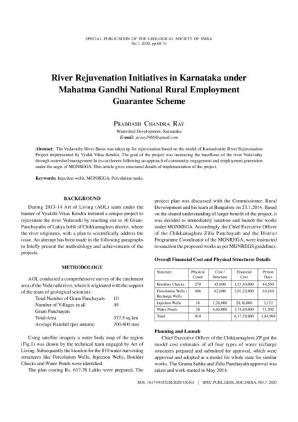
The Vedavathy River Basin was taken up for rejuvenation based on the model of Kumudvathy River Rejuvenation Project implemented by Vyakti Vikas Kendra. The goal of the project was increasing the baseflows of the river Vedavathy through watershed management In its catchment following an approach of community engagement and employment generation under the aegis of MGNREGA. This article gives structured details of implementation of the project.
River Systems and Other Surface Water Bodies of East-Central India: Their Status and Management Needs
SKU:
C-62881
The health of major river systems and other surface water bodies of East-Central India has been discussed. The geological conditions such as lithological variation, their weathering resistance, presence of rift valleys and tectonic trends have decided watershed conditions, which have controlled formation of river systems in East-Central Indian region. The development of Vindhyan Range, Satpura Range, Maikal Hills, Kaimur Hills, Eastern Ghat ranges, Chhotanagpur and Bastar plateaus in East-Central India have given birth to many big rivers e.g., Narmada, Son, Damodar, Mahanadi, Wainganga-Pranhita etc. The presence of major rift zones such as Narmada-Son-Damodar Rift, Mahanadi and Godavari rifts have guided the courses of almost all rivers in the region. The Vindhya-Satpura Ranges and Chhotanagpur Highland have separated the north Indian drainage from south Indian drainage systems. Except for the Himalayan Rivers, which are mostly snow fed, other rivers of India are monsoon fed and become dry during most part of the year causing difficulty to the society. The flow and storage of most rivers are becoming deficient day by day due to extensive siltation.Besides these major rivers, other surface water bodies such as lakes, artificial reservoirs, swamps, wetlands, canals and traditional water harvesting structures are also reducing or becoming defunct due to siltation, pollution, dumping of waste, illegal conversion for other uses and overall neglect by the society. In view of population growth, rapid industrialization and urbanization there would be more pressure on water bodies. Climate change would bring variability in monsoon rainfall which will have its impact on water resource. Unless extreme care is taken to save all the variety of water bodies, there would be severe water crisis in future in the country. A new national water policy is now needed to maintain country's water resource for its sustainability.
River Systems and Water Resources of West Bengal: A Review
SKU:
C-62893
West Bengal (88,752 km2) is the only Indian state that extends from the Himalaya to the Bay of Bengal. It can be divided into nine physiographic provinces of which the Himalayas, the western plateaus, the northern and western alluvial fans and the Ganga delta are the most important. The development of the river system of the state was largely governed by tectonic evolution of the eastern Himalaya and western edges of the Bengal basin. The characteristics of the rivers as well as a number of aspects of water resources of the state can be linked to its physiographic regions. The principal issues associated with water in West Bengal include river degeneration, channel shifting, flood, urban waterlogging, drought, pollution, groundwater depletion and inland navigation. The management of water is practised by river impoundment projects in various scales and by drainage schemes. It is estimated that the western and eastern parts of the state are the most water stressed regions due to climatic and human factors respectively. The solutions for many of the water-related problems of West Bengal, progressive or cyclic, can be achieved by putting emphasis on participatory management besides organisational intervention.
Role of Geotechnology in Groundwater Recharge and River Rejuvenation Works
SKU:
C-156160
Geotechnology has a significant role to play in recharging the groundwater by arresting the surface runoff , thereby, allowing the water to penetrate the ground. This paper highlights the importance of geotechnology in river rejuvenation and discusses geotechnical schemes for ground recharging. The artificial techniques can be used for groundwater recharge, which can be classified as surface methods and sub-surface methods. This paper briefly discusses artificial groundwater recharge techniques and geotechnical considerations associated along with the methods to reduce flow velocity of the surface and subsurface water. Groundwater hydrology, soil/rock characteristics, and permeability are the major factors governing the efficiency of groundwater recharge techniques. Surface methods enhance groundwater infiltration by providing more residence time with the help of structural and nonstructural measures. Subsurface structures enhance the infiltration of water into the aquifer. This paper also discusses the concept of the subsurface dike or underground dams and its applicability in storing a large amount of water underground to ensure base flow in streams. Different materials with significant applications in groundwater recharge through geotechnology are also discussed in brief.
Role of Submarine Groundwater Discharge in Coastal Aquifer Management
SKU:
C-165450
Submarine groundwater discharge (SGD) reportedly influences the global coastal environment significantly and Indian coast is not an exception. There are strong evidences to the fact that many land derived contaminants like carbon, nutrients, organics, metals and pathogens affect chemical and biological processes of near shore region, wherever SGD occurs. Further, the intensity of mixing and exchange increases depending on the residence time available during recirculation of SGD. Thermal infrared images allow us to monitor physico-chemical changes in land-ocean interface as well as to spatially map the submarine groundwater discharges, particularly through unconfined aquifers. This study attempts to identify and compute the total volume of SGD across selected sites in SW coast and also investigate the intensity of mixing using different parameters like temperature, salinity and radon in groundwater and pore water. There are reports that salinity reduction and excess nutrients induce eutrophication, mudbanks and algal blooms. On quantification of freshwater discharges in such anomalous zones, optimum pumping of groundwater from respective coastal aquifer layers can be advocated. Also release of nutrients and other pollutants through freshwater discharge can be monitored using sensor-based permanent piezometers, as management options.

Scope for Conjunctive Use and Interlinking of Rivers in Assam
SKU:
C-165839
Not with standing known contamination of groundwater by inorganic contaminants like arsenic and fluoride, a major proportion of rural communities in Assam relies on groundwater as a source of drinking water. First revealed during 2004, a comprehensive picture of groundwater contamination from arsenic in the Brahmaputra Valley emerged during a collaborative study by IITG-UNICEF and PHED, Assam. The study revealed that in 29% of a total 56,180 public sources analyzed arsenic content is above the threshold value of 10 ppb (WHO/BIS) exposing a huge unguarded population to the risk of arsenic contamination and resultant health hazard. It also brought to light a zone along the southern bank of the Brahmaputra River where arsenic levels were much above the recommended values. Public Health Engineering Department (PHED) of Assam initiated one of the grandiose piped water supply schemes for the state , where surface water from two major tributaries of Brahmaputra, the Dhansiri and the Doiang Rivers, are used for supply of arsenic free safe water to a designed population of 1, 90,000. While adequate surface water availability in the vicinity of such high arsenic contaminated aquifers have provided a viable alternative, this is infeasible in areas with discreet contaminated groundwater with scarce surface water sources nearby. Solutions like integration of rainwater harvesting structures, water recharging, delineation and safeguarding safe aquifers, reuse and recycling, water saving technologies, smart systems and conjunctive use then form part of a composite option necessitated for addressing the gaps and inadequacies in ensuring safe drinking water in the region.
Scope of Groundwater Conservation in Kerala: Case Studies and Policy
SKU:
C-165449
The State of Kerala receives an average annual rainfall of about 3000 mm and has forty-four rivers in addition to many surface water bodies. Though the overall groundwater resource situation in the State is not causing any serious concern at present, there are areas where water scarcity is being felt, especially during summer months, due to a combination of topographic, geologic, hydrogeological and anthropogenic factors. The monsoon recharge in phreatic aquifers is low due to the limited thickness of aquifers which is about 7 m on an average and water level fluctuation of less than 4m in 80% of the area. Because of this low storage space, the stored water gets exhausted or greatly reduced whenever there is a delay in the onset of monsoon. The State experiences hydrological drought frequently as a consequence of this feature. Moreover, in the midlands and high lands, characterized by undulating topography and high gradients, the base flow is relatively high. The study pertains to an evaluation of the scope of groundwater conservation in various aquifer systems and the efficacy of groundwater conservation practices and policies in the State given the above issues.
Sediment Characteristics and Foraminiferal Distribution in the Bet Zone of the Great Rann of Kachchh, Western India
SKU:
C-63299
Based on geomorphological characteristics, the vast, flat saline tract of the Great Rann of Kachchh is considered as a raised floor of a former gulf that was connected to the Arabian Sea in the west. In general, the Rann exhibits a unique supratidal environment complicated by alternating periods of marine and freshwater inundation and extreme dryness. The Great Rann is divisible into four distinct geomorphic domains - the Banni plain, the Linear trench zone, the Great barren zone and the Bet zone. Contrary to the rest of the Great Rann, the Bet zone shows distinct variations in elevation due to the presence of bets (islands) and is dotted by several vegetated elevated areas, seasonal short distance channels and local depressions. The present study attempts to characterize the environmental conditions of the Bet zone comprising the northwestern part of the Great Rann. Surface sediment samples were collected by digging small pits in the Rann surface at several locations along ESE-WNW and roughly N-S oriented transects (transect 1 and 2). The samples were subjected to detailed grain size analysis and micropalaeontological analysis for determining foraminiferal assemblage. Overall, the sediments of the Bet zone are of sandysilty to clayey-silty in nature. The grain size was found to vary in accordance with the microgeomorphic setting of the stations. The foraminiferal assemblages recorded along the two transects belong to twelve genera (Ammonia, Elphidium, Bolivina, Nonian, Bulimina, Cibicides, Helenina, Brizalina, Globigerinella, Globigerina, Globorotaloides Gallitellia). Presence of some reworked foraminiferal tests suggests the transport of foraminifera from the Arabian Sea water surges under the influence of strong SW monsoon winds. However, the relatively higher diversity near the open ocean gets reduced in the Great Rann due to the typical hypersaline conditions, submergence patterns, mixing by fresh water (runoff, fresh water influx), and the microenvironments created by variations in the elevation of the Rann surface. The diversity is limited to the few tolerant taxa which can survive through such large scale changes in the environmental parameters.
Sequence Stratigraphic Analysis of a Shallow Marine, Mixed Carbonate-Siliciclastic System, Early Miocene, Kutch
SKU:
C-105411
The Early Miocene succession in Kutch (western India) is represented by a mixed carbonate-siliciclastic system. A combined sedimentological, trace fossil assemblage and micropaleontological analysis of the succession was carried out to refine sequence stratigraphic architecture. In this mixed carbonate-siliciclastic system, the trace fossil complement the micropaleontological data in the carbonate portion and provide crucial information in the siliciclastic part, particularly in identifying key stratal surfaces. The sedimentary succession records single cycle of third order fluctuation in relative sea-level (~7 Ma.) with higher order fluctuations of million year episodicity. The preserved sequence is asymmetric, consisting of a thick transgressive systems tract (TST) and a relatively thin highstand systems tract (HST). The transgressive systems tract exhibits a gradual change in foraminiferal assemblage indicating deepening upward succession in overall middle shelf environment. The trace fossils change from Psilonichnus ichnogenera to Skolithos assemblage to Thalassinoides assemblage, from the base of the section to the top. The reworked burrow tubes of Psilonichnus ichnogenera concentrated in the lower part of the TST indicates lag concentration, accumulated during onset of the transgression. The recurrence of larger foraminifera and trace fossil attributable to the Thalassinoides assemblage at various stratigraphic levels (i.e. upper part of TST and lower part of HST) marks the higherorder flooding surfaces and base of parasequence. A high abundance of planktonic foraminifera, including Cassigerinella, Globigerina and Globorotalia, characterizes the maximum flooding surface (MFS) corresponding to a maximum bathymetry of ~50m. The progressive shallowing in highstand systems tract exhibit siliciclastic dominated succession with increased coarse clastic sediments towards top and it is marked by a gradual decrease in the abundance of ichnogenera and shallow water foraminifera and their absence in the upper part of the HST.
Sequence Stratigraphic Analysis Of the Mixed Siliciclastic-Carbonate Sediments (Middle Jurassic) Of the Patcham Island, Kachchh, Western India: An Ichnological Approach
SKU:
C-63292
The Middle Jurassic (Bajocian to Callovian) sequence of the Patcham Island, Kachchh, comprises mixed siliciclastic-carbonate sediments displaying transgressive-regressive cycles that record changes in the relative sea level condition. These mixed siliciclastic carbonate sediments are of varying composition representing six sedimentary facies namely, micritic sandstone, allochemic sandstone, sandy allochem limestone, sandy micrite, muddy micrite, and micritic mudrock along with the grey shale, allochemic limestone and ferruginous sandstone facies. These sedimentary facies are bioturbated with a total of 65 ichnospecies of 42 ichnogenera which are recurring throughout the sequence. The trace fossils are further grouped into nine trace fossil assemblages based on environmentally related traces based on diversity, frequency and preservational aspects (viz., Arenicolites, Asterosoma, Gyrochorte, Ophiomorpha, Planolites/Palaeophycus, Phycodes, Rhizocorallium, Skolithos and Thalassinoides assemblages). The sedimentary units (packages) coupled with ichnoassemblages reveal three transgressive system tracts (TST) and four regressive system tracts (RST) separated by flooding surfaces representing 3rd order transgressive-regressive (T-R) cycles bounded by regressive surfaces. In the T-R cycle, presence of the Rhizocorallium ichnoassemblage (TRC-II) and Arenicolites, Thalassinoides with Planolites-Palaeophycus assemblages (TRC-III) mark the flooding surfaces while the Skolithos assemblage with the Planolites-Palaeophycus assemblage (TRC-I), Arenicolites assemblage (TRC-II) and Planolites-Palaeophycus assemblage (TRC-III) mark the regressive surfaces. These soft ground ichnoassemblages mark the Skolithos and Cruziana ichnofacies conditions developed in progradational and retrogradational sequences and indicate cyclic changes in bathymetry within shoreface-offshore settings. An integrated sedimentological and ichnological approach has allowed the recognition of the internal organization of the sequence in absence of significant physical expressions of discontinuity surfaces at the T-R cycle scale.
Sequence Stratigraphy Of Late Cretaceous Successions In the Ramnad Sub-Basin, Cauvery Basin, India
SKU:
C-63294
We interpret the subsurface distribution pattern of Late Cretaceous sandstone reservoirs in the Ramnad sub-basin within the framework of sequence stratigraphy via biostratigraphic and lithostratigraphic correlation with outcrop sections in the Ariyalur area of the Cauvery basin. The sequence stratigraphic surfaces recognized in outcrop sections can be correlated to subsurface sections by using biostratigraphic datum markers. By this method five 2nd and 3rd order sequences can be recognized in outcrops of the Ariyalur area based on sequence boundaries (SB): 1) the top of the Terani Formation (latest Aptian-earliest Albian SB1), 2) the Karai Formation (middle Turonian Marginotruncana sigali Zone SB2), 3) the Anaipadi member of Garudamangalam Formation (late Santonian Dicarinella asymetrica Zone SB3), 4) the Sillakudi Formation (late Campanian Globotruncanita calcarata Zone SB4), 5) the Ottakovil Formation (early late Maastrichtian Gansserina gansseri Zone SB5), and 6) the Kallamedu Formation (late Maastrichtian Abathomphalus mayaroensis Zone SB6). Examination of log profiles of the Koluvur, Ramnad, Perungulam, Chumaitangi, Kanjirangudi, Periapattinam, Ramanavalasai and Uchipuli structures show that sea level lowstands at the end of the middle Turonian, late Santonian and late Maastrichtian are associated with coarser clastic sediments in deeper parts of the basin. This suggests that low sea levels are associated with bypass of coarser clastics in shelf areas and deposition as fan deposits in the deeper parts of the basin. Major sea level falls thus significantly influence the distribution of coarser clastic sediments and the application of sequence stratigraphic concepts aids the understanding of sandstone reservoirs in the Ramnad sub-basin.

SkyTEM ? A Highly Efficient Helicopter-Borne TEM System
SKU:
C-95955
A modern helicopter-borne transient electromagnetic ("HTEM") system like SkyTEM can be used for many different applications such as aquifer mapping, mineral exploration, and geotechnical engineering. This broad range of applications necessitates, however, that the technology is versatile and fulfils essential criteria like good near-surface resolution, high signalto-noise ratio, and cost-effective operations. This paper demonstrates how SkyTEM systems are designed to accommodate these technical requirements. Furthermore, examples of utilization of SkyTEM systems for various applications will be shown.

Soil Conservation, Crop Water Planning and its Use Efficiency in Rainfed Agriculture
SKU:
C-95946
Soil and water are the major natural resources endangered with erosion, which need to be conserved for existence of life. Soil and rainfall characteristics in the state is highly diversified, necessitating efficient conservation. In-situ conservation practices can help in low rainfall areas to protect these resources. Ex-situ conservation practices are essential in sustaining agriculture in rainfed ecosystem and safe disposal of excess water is the concern in high rainfall coastal areas. Contour farming, deep tillage once in 2-3 years under crop rotation using tractor drawn implements like Disc Plough, Mould Board Plough and Chisel Plough, inter-terrace management through bunding and vegetative barriers based on the rainfall intensity, slope and texture of the soil, broad bed furrows in black soil, moisture conservation furrows/dead furrows, mulching with crop residue/ weeds, community based water harvesting structures, scooping can help for conservation of soil and water resources. Planning crops depending on the length of growing period, efficient use of water through the adoption of micro-irrigation, conveying through pipes, conjunctive use with rain and poor quality water, irrigation at critical stages, diversified cropping based on land use capability, water availability period and contingent practices under weather aberrations can help for improving the productivity and water use efficiency.
Status of Rivers in Tamil Nadu: Problems and Perspectives
SKU:
C-62888
Water is the prime resource responsible for sustaining life in the earth. Water within a river basin has to be properly allocated for various uses like generation of electricity, domestic supply, for irrigation, for industrial use, and in some cases for recreation as well. On par with this is the disposal of domestic waste, effluents and other pollutants forming the other side of the water distribution. To add to these are the vagaries of monsoon affecting the basin by extreme drought or flood. Rivers of Tamil Nadu can be grouped into 17 river basins (127 sub-basins) a majority of which are water-stressed. The average annual rainfall is 950 mm with bimodal distribution. Water Balance equation is the general term used to describe the flow of water in and out of a river system. It is illustrated using a water balance graph which plots the precipitation, evapotranspiration on a month wiseinterval. Classification of river basins into surplus basins and deficit basins is the prime requirement for allocation of water in various sectors and exchange of water from surplus basins to the deficit basins. This paper highlights the ways and means to restore, revive and replenish the available water resource in a judicial manner. To some extent the location and nature of surface water bodies (rivers, lakes, tanks, and reservoirs) are controlled by the geology and geomorphology (land forms) of the area and some data is provided on this aspect as well of the study area.
Status of Surface Water Resources of Kerala ? Development and Management Issues, Future Strategies
SKU:
C-165439
Kerala State is a narrow strip of land situated on the south-west coast of India with the Western Ghats as its eastern boundary. The State experiences a humid tropical climate and receives an average annual rainfall of 3000 mm, which feeds all the water bodies in the State. Rising population, urbanization, industrialization, changing life style of people, etc. is increasing the freshwater demand in Kerala every year. Water management in Kerala is a difficult task due to high spatial and temporal rainfall variations, undulating topography with steep slope towards sea, high population density, lengthy coastal stretch with saline backwaters and estuaries, climate change, etc. The State faces recurring floods and droughts, pollution in freshwater bodies, salinity intrusion/ingress in rivers and coastal aquifers, etc. In the context of spatial and temporal variations in water availability, increasing water pollution and the steady increase in water demand over the years, the State should have scientific water conservation and management strategies aimed at the improvement of surface water and groundwater availability, mitigation of flooding during monsoon, prevention of water pollution and improvement of the water quality, improvement of water use efficiency, prevention of unscientific land use changes, creation of water awareness, rainwater harvesting and also the wise and efficient use of freshwater resources, etc. Status of surface water resources of Kerala, its development and management issues and future management strategies are presented here.
Strategies for Ground Water Resources Management to Facilitate Water Security in Gujarat
Conference Papers, SP-12: Water Resources of Western and Central Regions of India: Status, Issues and Strategies
SKU:
C-168756
As per the assessment of the dynamic ground water resource in Gujarat the utilsable ground water resources have been assessed as 24905 MCM, after providing for natural discharge (March 2021). The annual ground water draft is 13296 MCM. The Stage of ground water development works out to be about 53%. However, this is not uniform across the state. The stage of development is exceedingly high in North Gujarat and Kachchh regions. Highly intensive development of ground water in these areas has resulted in over - exploitation leading to the decline of ground water levels, deterioration in the ground water quality and sea water intrusion in the coastal areas. The paper presents existing scenario of various supply and demand side interventions implemented in the state with their impact. Recommendations for various interventions necessary for sustainable ground water management have been made with particular emphasis on use of scientific inputs from the supply as well as demand side interventions to the community participation in planning, implementing and monitoring.
Stratigraphy and Depositional Environment of Sediments of the Goradongar Formation, Goradongar Range, Patcham Island, Kachchh
SKU:
C-105407
The Middle Jurassic (Bathonian-Callovian) rocks of the Goradongar Formation of the Goradongar range ~144.4 m thick succession constitutes of Goradongar Flagstone, Gadaputa Sandstone, Raimalro Limestone and Modar Hill members in an ascending order. The successions contain variable thick bands of pure clastic (arenaceous), non-clastic (allochemic limestone), mixed siliciclastic-carbonate rocks, shales and intraformational conglomerates. Mixed siliciclastic-carbonate sediments dominate the succession which are further classified according to their compositional variation and identified as micritic sandstone, allochemic sandstone, sandy allochem limestone, micritic mudrock and sandy micritic. The mixed siliciclastic-carbonate succession of the formation is intercalated by shales; and at certain stratigraphic levels it becomes pure clastic or non-clastic. The nonclastic successions are further analysed for microfacies which includes pelloidal grainstone, bioclastic grainstone, bioclastic packstone, pelloidal packstone and oolitic packstone. These rock units are characterized by sedimentary structures such as planar laminations, cross bedding and ripple (wave and current) marks; while certain bands are highly fossiliferous and bioturbated which display change in depositional regime. Variation in sediment composition, textural immaturity, and associated sedimentary structures of the Goradongar succession indicate the fluctuations in rate of sediment supply, energy levels and bathymetric conditions; and suggest two depositional regimes: lower shoreface to offshore transition and offshore.

Strontium Isotope Stratigraphy of the Naredi Formation, Kutch Basin, India
SKU:
C-63304
The Naredi Formation records the first marine transgression of the Cenozoic era in Kutch. Its age has remained equivocal and various workers have assigned different ages ranging from Late Palaeocene to Early and Middle Eocene. In this study we carried out strontium isotopic analysis of the foraminiferal shells of the Naredi Formation to determine its numerical age in order to resolve this controversy. The measured 87Sr/86Sr ratios, lying between 0.707727 and 0.707816, have been compared with the standard strontium isotope variation curve for the Cenozoic. Biostratigraphically, the formation ranges from shallow benthic zone SBZ 6 to SBZ 11 corresponding to planktonic foraminiferal zones P5 to P9 (Serra-Kiel et al., 1998). The biostratigraphically constrained Sr isotopic values indicate that the Naredi Formation is of Early Eocene age spanning from 50 to 55Ma.
Study of Wax Inhibition in the Indian Waxy Crude Oil by Polarizing Microscope and its Effect on Rheology
SKU:
C-95906
This research article deals with the effect of thermal conditions on the size and morphology of waxy crystals in the Indian crude oil and their influence on the rheological property at different temperatures. The effect of concentrations of flow improvers on the rheology of waxy crude oil has also been studied. Two commercial pour point depressants are used to show the effect of additives on waxy crude oils.The images of wax crystals are taken at various temperatures for both virgin and additivetreated crude oil. Both temperature and additive treatment affect the size and morphology of crystals. Wax crystals have little influence on the rheological properties of the oil at high temperature because the sample is a dilute suspension at this temperature. As the sample was cooled to lower temperature, more wax crystals appeared, with very little agglomeration at first. These crystals were also increasing in size. Due to the wax crystals, the oil acts as a dispersive suspension. Agglomeration between particles becomes common and a lattice is formed and all neighboring agglomerates appear to be connected to each other. The network between wax crystals can be more clearly observed at lower temperatures. The waxy structure at this temperature is more likely to be a porous medium with a continuous phase of solid wax and a dispersed phase of oil base. In case of additivetreated crude oil, wax crystals do not agglomerate even at lower temperatures, which shows that treated crude oils are both pumpable and flowable at even low temperatures which is not the case in neat crude oil. Also, from rheological studies it is shown that additive-treated crude oil require less shear stress i.e less power consumption for transportation.
Study on Spectral Signature of Kaolinite {Al2Si2O5(OH)4} from Bageshpura Clay Mines, Hassan District of Karnataka
SKU:
C-95910
Hyperspectral remote sensing is an advanced and up-coming technology in the field of remote sensing. The Geological Survey of India (GSI) has taken a lead in building up a comprehensive spectral library for rocks and minerals for the entire Indian sub-continent in line with the spectral library of the United States Geological Survey (USGS) and the Jet Propulsion Laboratory (JPL). The readymade spectra of minerals (including ore minerals) and rocks (altered and unaltered) could help in the identification of the mineralogical composition of an unknown area and ultimately in targeting the mineralised zones. The study is aimed at the spectral signature of kaolinite in both the solar illumination in the field and in artificial illumination (tungsten quartz halogen lamp) as source in the laboratory condition. The diagnostic absorption features of kaolinite in visible and NIR wavelrngh (0.35-2.50 ?m) are unavailable in the conventional remotely sensed data specially at 1.40 ?m and 1.90 ?m because of atmospheric obscuration. Kaolinite shows intense absorption at 1.396, 1.413, 1.913, 2.166 and 2.209 ?m and comparatively less absorption features at 0.37, 0.97, 2.327, 2.356, 2.385 ?m. The slightly broad absorption feature at 1.396 ?m with a sharper band at 1.413 ?m is because of the OH stretch overtones and features at 2.166 and 2.209 ?m are because of Al- OH bend plus OH stretch combination. Doublet at 1.40 and 2.20?m is characteristic of kaolinite.
Subsurface Coal Fire Mapping in Patherdih Colliery, a Part of the Jharia Coal Field, India
SKU:
C-95899
Coal fires are a universal problem in worldwide coal mining areas. They burn out precious coal resources, hinder mining activities and pose a danger to man and machine, besides leading to environmental pollution and land subsidence problems. In this context, high resolution magnetic survey offers a powerful tool for the detection, delineation and monitoring of coalfires. The Jharia coalfield in India is known for its high grade coal and associated coal fires. The valuable coal reserves are destroyed in the subsurface due to fire, before their exploitation. The present study deals with the mapping and understanding of subsurface coal fire on the basis of magnetic properties of materials and their changes with temperatures above or below the Curie temperature. The coal burning heat rising above Curie temperature results in a loss of natural magnetism in nearby area. Small regions, called domains, within the crystal structure reorient themselves which upon cooling; align themselves more or less in the direction of the ambient magnetic field. This remanent magnetism may be several orders of magnitude greater than the natural magnetism. The minerals which are formed and their respective magnetic strengths depend on the temperatures reached and the amount of oxygen available. Magnetic data acquisition has been carried out using high resolution GSM-19T proton precession magnetometer in gradient mode. The acquired magnetic data have been processed and analyzed using Geosoft Oasis Montaj software to study magnetic field anomaly of Patherdih Colliery in Jharia coal field, India for mapping and understanding of subsurface coal fire. The processed data provide a clear indication of location of active coal fire affected area. This repeated study could help for characterization of dynamics of coal fire of the region.
Surface and Ground Water Resources of Maharashtra: Status, Management, Governance Issues, and Future Policy
Conference Papers, SP-12: Water Resources of Western and Central Regions of India: Status, Issues and Strategies
SKU:
C-168751
Air, Solar energy, Land, and Water are the four life support systems of which, only ?Water? is amenable for its development and management to meet human needs of water. Water Resource Development structures had to be compatible to the characteristics of ?Water Resource?. With the advancement of civilization, ingenuity of man prompted him to evolve different types and sizes of infrastructure to meet changing patterns and increasing magnitude of water demand. It also stressed the need to have an integrated approach in such development. Subsequently as a soft option, improvement in management of infrastructure was the next logical step. As the issue of complexities in the competing and conflicting demands on water surfaced prominently, need for taking a holistic approach towards them was thought of and there emerged the viable solution in the form of better governance of water resources. An attempt has been made here in below to present evolution of all these developments by citing a case study of Maharashtra State in the Peninsular India. It mentions at the end a ?Vision Statement? for the future development of the State in the water sector and an outline of future planning and policies which need to be adopted. In conclusion it states a framework of desirable actions to be taken in future, to transform the ?Vision? into a reality.
Surface Water Resources and River Systems of Andhra Pradesh
SKU:
C-62885
Andhra Pradesh like many other states of India is a riverine state with two major rivers - the Godavari and the Krishna - and, three medium size rivers - Penner, Nagavali, Vamsadhara - along with many other minor streams, flowing through it, and it is the 'rice bowl' of India. With average annual rainfall at 940mm, Andhra Pradesh yields good amount of surface waters. The Central Water Commission has worked out the potential of surface water (78.9 km3) of Andhra Pradesh, and in the present study an attempt has been made to map various surfaces - lithology, geomorphology, land use and soils - on which runoff coefficients depend and to calculate the surface water potential rainfall zone-wise. Run-off coefficients of various units under the listed themes are averaged through overlay analysis in ArcGIS and the surface water potentialis calculated and the potential stands at 100.24 km3. Implications of lithology, geomorphology, soils and land use on various aspects to rejuvenate river systems are also discussed in detail.
Surface Water Resources of Chhattisgarh: An Overview
Conference Papers, SP-12: Water Resources of Western and Central Regions of India: Status, Issues and Strategies
SKU:
C-168763
The Chhattisgarh state covers a total geographical area of about 135192 Sq. Km with subtropical climate, characterized by extreme summer and moderate winter having average rainfall of about 1300 mm. Physiographically, the area is characterized by three distinct landforms namely Bastar plateau in the South, the plain of Mahanadi river and its tributaries in the central part and the hills of Chhotanagpur plateau in the northern region. The major river basins in the state are Brahmani, Godavari, Ganga, Mahanadi and Narmada . The total catchment of these river basins is about 13559 kilometers. The Mahanadi Basin is the largest basin covering an area of about 76150 square kilometers out of 141589 square kilometers, nearly 4.3 percent of total geographical area of the country. Chhattisgarh has 2 percent population and 3.2 percent of total surface water resources of the country. The utilizable surface potential in the state if properly harnessed can irrigate about 4.3 million hectares area against the existing potential of 1.38 million hectare. Due to various anthropogenic activities, urbanization, industrialization etc, the quality and quantity of water have been adversely affected. The rivers Hasdeo, Indravati, Kharun, Apra etc. are polluted due to industrialization and urbanization in various parts of the Chhattisgarh. To check the pollution, proper management of solid/liquid waste of various industries is needed. Beside these, use of biofertilizers instead of chemical fertilizers, pesticides etc should be promoted. Effective water management strategies combined with watershed treatments like soil conservation, afforestation, desilting of rivers, rainwater harvesting etc are needed to maintain the health of the river basins of Chhattisgarh. The Jal Shakti Abhiyan started by the Government of India is a highly welcome move in this direction.

Surface Water Resources of Karnataka – Uncertain Quantum and Stressful Scenario
SKU:
C-62867
The State of Karnataka covers an area of 190498 km2 with a population of 61 million. Geologically, the state is covered by Archaeans, Proterozoic sediments, basalts of Deccan Trap Province and alluvium of Recent age. The Western Ghats, Karnataka Plateau and Coastal Landforms are the major geomorphic features of the state. In spite of seven river systems and 36,753 tanks in Karnataka, 67 percent of the land falls under dry tracts. Estimates are available for the average yield of river basins of the state. The quantum of water available in a water year for utilization appears to be beyond assessment because of erratic behaviour of rainfall and Inter-State River Water disputes. The poor management of catchment area, siltation of water bodies, poor management of distribution network, abuse and misuse of resources are the other factors for the stressful situation. The impact of climate change on the water resources cannot be ignored. To cater to the needs of growing population, the available water has to be protected, improved and managed efficiently. The approach should be holistic including soil specific agricultural practices, judicious use of water and awareness of stressful situation of water resources. Since the Krishna and Cauvery basins are "Closed Basins," the riparian states should have positive approach in the interest of the people.
Surface Water Resources of Kerala: Key Policy Issues and Management Strategies
SKU:
C-165448
Though the tiny state of Kerala in South India appears to be extraordinarily rich in water resources, there are several challenges associated with its sustainable management. Recent occurrences of extreme climatic events in the form of heavy rainfall over noticeably short periods, signify the urgent need for Integrated Water Resource Management (IWRM) in the state. Revisiting the state water policy in this context needs wider consultations and more meaningful deliberations. Along with a broad overview of the surface water potential of the state, this paper discusses some of the important concerns that are to be addressed with adequate policy responses. Pollution abatement, ensuring adequate environmental flows in the river basins, having the Water Resources Information System (WRIS) in place, revisiting its interstate water sharing pacts, grooming the real time integrated operation of its reservoirs, and rolling out conjunctive water management plans are all vital. Equally vital are the plans to improve water conservation, propagating community micro irrigation systems and adopting climate resilient cropping. Setting up the appropriate institutional arrangements and enabling the environment for IWRM must be crucial for the state in this perspective.
Surface Water Resources of Madhya Pradesh: An Overview
Conference Papers, SP-12: Water Resources of Western and Central Regions of India: Status, Issues and Strategies
SKU:
C-168761
Madhya Pradesh is endowed with sufficient surface water. This water is available to the state thorough perennial rivers Narmada, Son, Tapti, Chambal, and Wainganga. These rivers also have numerous perennial tributaries. The total surface water availability in the Chambal, Betawa, Ken catchment is 45 cubic km; 29.29 cubic km in the Son catchment; 52.43 cubic km in the Mahanadi river catchment; 40.83 cubic km in the Narmada catchment and 4.53 cubic km in Wainganga and Pench catchment. Madhya Pradesh received erratic precipitation during the last five years . So it does not have sufficient surface water. The need is for proper management of available surface water resources including systematic monitoring and water conservation techniques. Involvement of Panchayats and other stakeholders is essential to augment surface water bodies through tanks and other rainwater impounding structures. It is time that the stake holders should be aware of the availability of resources for future use, and benefits of conjunctive use of surface and groundwater.
Surface Water Resources of Maharashtra: Potential, Development and Management Issues
Conference Papers, SP-12: Water Resources of Western and Central Regions of India: Status, Issues and Strategies
SKU:
C-168752
The water sector in Maharashtra is facing critical challenges. First, uneven availability of water over space and time is the biggest challenge and secondly, dramatically increasing competing demands for water from different sectors are giving rise todisputes and conflicts. Of the total water used in the state, about 82% goes to irrigation, 12% for domestic water supplies, 4% forindustrial use, and the remaining for other uses such as livestock, hydro and thermal power generation. With the urban population of about 51 million (45%), and rapidly growing urban centres and industries, there is considerable gap in demand and supply of thestate's scarce water resources. This has posed serious challenges to water security. There can be only limited dependence upon the groundwater resources for the protective irrigation in the State as 85% area is Deccan basalt having limited ground water recharge potential. Also access to safe drinking and other domestics is a challenge in the rural areas of the State. Planning and Management of water resources in a coordinated and holistic manner is needed. Considering the scarcity of water in large part of Maharashtra and substantial utilisation by irrigation sector, there is a need to expedite measures for improving Water Use Efficiency (WUE) so that water saved in irrigation can be utilised for other non-irrigation purposes. The paper gives an overview of the water resources scenario in Maharashtra with reference to surface water and discusses various water management issues that need focused attention. The paper brings out the impact of decision of various water dispute tribunals on the water availability for the State and also the need for inter-basin and intra-basin water transfer. It emphasises the need for upscaling use of Micro Irrigation (MI), Pipe distribution system, large scale integrated MI systems throughout the State etc. for not only to save substantial amount of water but also to help in increase the productivity and quality of agriculture produce. The paper also touches upon the issues of water quality and flood management in the State.

Surface Water Scenario in Rajasthan State, India
Conference Papers, SP-12: Water Resources of Western and Central Regions of India: Status, Issues and Strategies
SKU:
C-168758
Surface water resources in Rajasthan are scarce and scanty owing to hot arid climatic conditions. Major parts of western Rajasthan are devoid of any major drainage system and are reeled under spells of chronic droughts. Average annual rainfall in the state is of the tune of 540mm, decreases westward and is even less than 150mm in the western most parts of Jaisalmer district. Annual Potential evapo-transpiration is also as high as 2060mm in parts of Jaisalmer district. There are 15 river basins in the state. There are also numerous natural as well as artificial freshwater lakes including Pushkar, Rajsamand, Nakki, Ana Sagar, Kayalana, Ramgarh, Foy Sagar etc. mainly in the southern and eastern parts of the state. Salt lakes include Sambhar, Kuchaman, Pachpadra, Didwana, Phalodi, Lunkaransar etc. Indira Gandhi Nahar (IGNP), Bhakara and Gang canals have been constructed to bring Himalayan water to the desert areas of western Rajasthan in addition to other major commands of Chambal, Mahi and Narmada canals etc. In Rajasthan, irrigation projects completed include 22 Major projects, 77 Medium projects, 660 Minor projects and 3139 Tanks have been transferred to Panchyat Raj Department. Usable water is of the magnitude of 16.05 BCM and the Gross Storage Capacity created is of the order of 14.547 BCM. The Live Storage Capacity created is about 11.99 BCM. Out of the total allocated share of 17.88 BCM under interstate water agreement, average annual water availability remains 12.66 BCM due to various climatic, political, institutional or hydrological reasons. In addition to various Central Government Schemes, Watershed schemes and Mukhyamantri Jal Swavlamban Abhiyan are also implemented in the state.
Sustainable Development and Management of Groundwater of Chhattisgarh: An Overview
Conference Papers, SP-12: Water Resources of Western and Central Regions of India: Status, Issues and Strategies
SKU:
C-168765
In general, Chhattisgarh state is underlain by hard rocks with limited groundwater potentials. But decline of rainfall in most parts of the state is limiting surface water resources too. Agriculture is mostly rainfed, paddy being the main crop in the state. Groundwater is the main source of irrigation and a major source of drinking water. Cavernous limestones/dolomites form the most potential aquifers yielding up to 50 lps as in Bastar, Baloda Bazar and Bilaspur districts. Proposal for construction of energized irrigation dug/bore wells under PMKSY-HKKP-GW scheme in 109 blocks (stage of extraction within 60%) of 7 aspirational districts will enhance ground water irrigation of 7467 ha land. The stage of extraction has already escalated from 5.11% (1990) to 44.43% (2017) which will be escalated further with ongoing and future development programs. The State should undertake conservation of groundwater through regulation, protection and augmentation of the water resources by implementing rainwater harvesting and artificial recharge, along with adoption of rainfed agriculture, drip or sprinkler irrigation, pricing policy for commercial ground water extraction, exploration and planned development of yet unknown aquifers through exploratory drilling aided by remote sensing, geophysics . Based on declining groundwater level trends areas totalling 16,410 sq. km have been demarcated for rainwater harvesting and artificial recharge creating sub-surface ground water storage potential of 1030.11 MCM and an additional irrigation potential of 148430 ha. Further, groundwater pollution from geogenic and anthropogenic sources like high fluoride, arsenic, uranium, sulphate, nitrate as in Rajnandgaon, Durg, Bilaspur, Raipur and Kwardha districts is also a potential threat to the utilisable resources.This paper attempts at a holistic overview of sustainable development and management of ground water resources of the state considering the huge hydrogeological, geophysical and chemical database in the state.