
SP-03: Rejuvenation of Surface Water Resources
Geomorphology of North-Western India (Marusthali to Narmada Valley Ending Up with Vindhyan Scarplands) with Special Reference to Surface Waters
SKU:
C-62870
Resource potential in space and time is dependent upon the hydro-geomorphic dynamics that include topography, precipitation and lithology. Regional geo-climatic conditions control the distribution and availability of water resources and their development requires a scientific evaluation of potential and terrain appropriate structures. In this context, the northwestern region of the Indian subcontinent has diverse geomorphologic characteristics ensuring a wide disparity in the distribution of surface water resource. The rivers are seasonal and the flow is dependent on the rainfall which varies from less than 100 mm in the arid land to more than 1000 mm in the eastern hilly areas. Based on the variations in these parameters, the area is divided into five hydro-geomorphic units 1) Dunal Plains of Thar, 2) Semi-arid to Arid Alluvial Plains, 3) The Eastern Hill Ranges, 4) The Plateau and Pediments (buried/exposed) and 5) Coastal Plains. The major issues in harnessing the surface water include seepage/evaporation losses in the plains and excessive runoff due to steep slopes and hard rock lithology in the hilly areas. Unavailability of water in the downstream due to damming of rivers, changing land use and obliteration of drains in the catchment of ponds are some human induced major issues in this region. Ample groundwater resource and advent of tube wells led to neglect of the existing water harvesting structures as well as surface water bodies, but now, the ground water is fast depleting. There is good surface water potential at least in parts of the region, but its rejuvenation needs impetus. The water availability and security can be improved adopting a basin perspective provided the resource is managed in a holistic and integrated manner at this level.
Geomorphology of the North Eastern Region of India with Special Reference to Surface Water Resources
SKU:
C-62879
The North Eastern Region represents a unique geophysical and ecological setup vis-a-vis the eastern Himalayas dominated by extremely dynamic earth processes, intensely potent monsoon rainfall regime, hyperactive seismicity and a fabulously rich biological and cultural diversity. The region is richly endowed with a vast water resource potential accounting for about one-third of the country's total water wealth although its utilization has so far been grossly limited. The Brahmaputra, a transboundary river originating in Tibet (China) and one of the world's largest and most complex alluvial river systems, drains a major part of the region. The Barak is another dominant river system flowing in the southern part of the region that eventually flows across the border to Bangladesh. The floodplains of these rivers are dotted with a large number of wetlands (locally known as Beels) that have considerable ecological, hydrological as well as economic significance. However, most of these wetlands are in degraded or derelict condition due to accelerated sedimentation, eutrophication, encroachment and various other anthropogenic factors. The study discusses different aspects of fluvial geomorphology in relation to the geologic and geotectonic frameworks of the region. An integrated basin planning and management approach seems to be the most appropriate paradigm for utilizing the vast water wealth of the region and mitigating its associated hazards. The geologic/geomorphic ideas and techniques are increasingly known to have great relevance in the management and conservation of rivers and other water bodies like wetlands, especially in the context of North East India.
Indus and Ganga River Basins in India: Surface Water Potentials
SKU:
C-62876
Life depends on water as much as it depends on air. Water received as rainfall gets collected in various storages and flows through the rivers. It is this water which has to be measured and managed to sustain adequate supplies for various uses and users (including plants and animals). To manage supply of water, accurate measurements on its availability are fundamental. Measurements depend on rainfall and types of various surfaces on which it falls. In the present work, various surfaces are mapped separately under four themes - lithology, geomorphology, soils and land use and using rainfall and various run-off coefficients average annual surface water yield is calculated for both the Indus and Ganga river basins within India. Various aspects of river systems are discussed in brief vis-a-vis lithology, geomorphology and soils. The paper as a corollary proves a point on the need of high accuracy measurements from large scale/high resolution maps and data. To some extent the location and nature of surface water bodies (rivers, lakes, tanks, and reservoirs) are controlled by the geology and geomorphology (land forms) of the area and some data is provided on this aspect as well of the study region.
Rejuvenation of Kerala Rivers: Geoenvironmental Setting, Potentials, Problems and Recent Initiatives
SKU:
C-62865
Kerala State can be broadly divided into three well definable zones, with high mountains of Western Ghats extending NW-SE in the east (Precambrian), a long narrow coastal plain in the west (Recent), flanked by Arabian Sea, and an undulating terrain (Precambrian and Tertiary) in between. Laterite in different forms is a ubiquitous rock in most of the places. River restoration has drawn considerable attention across the world as river systems are variously affected due to human intervention and in many cases irreversible changes have taken place. Due to high population density, with intense use of land and indiscriminate resource extraction, rivers in Kerala are under stress as has been reported in various studies. Restoration plan warrants proper understanding of the river system. This paper discusses various geo-environmental issues that impact the river system. Physical characteristics of the rivers have been deliberated and problems are identified. It is suggested that restoration of rivers warrants catchment scale approach considering all parameters, local initiatives like river bank mapping and involvement of all stake holders.
River Systems and Other Surface Water Bodies of East-Central India: Their Status and Management Needs
SKU:
C-62881
The health of major river systems and other surface water bodies of East-Central India has been discussed. The geological conditions such as lithological variation, their weathering resistance, presence of rift valleys and tectonic trends have decided watershed conditions, which have controlled formation of river systems in East-Central Indian region. The development of Vindhyan Range, Satpura Range, Maikal Hills, Kaimur Hills, Eastern Ghat ranges, Chhotanagpur and Bastar plateaus in East-Central India have given birth to many big rivers e.g., Narmada, Son, Damodar, Mahanadi, Wainganga-Pranhita etc. The presence of major rift zones such as Narmada-Son-Damodar Rift, Mahanadi and Godavari rifts have guided the courses of almost all rivers in the region. The Vindhya-Satpura Ranges and Chhotanagpur Highland have separated the north Indian drainage from south Indian drainage systems. Except for the Himalayan Rivers, which are mostly snow fed, other rivers of India are monsoon fed and become dry during most part of the year causing difficulty to the society. The flow and storage of most rivers are becoming deficient day by day due to extensive siltation.Besides these major rivers, other surface water bodies such as lakes, artificial reservoirs, swamps, wetlands, canals and traditional water harvesting structures are also reducing or becoming defunct due to siltation, pollution, dumping of waste, illegal conversion for other uses and overall neglect by the society. In view of population growth, rapid industrialization and urbanization there would be more pressure on water bodies. Climate change would bring variability in monsoon rainfall which will have its impact on water resource. Unless extreme care is taken to save all the variety of water bodies, there would be severe water crisis in future in the country. A new national water policy is now needed to maintain country's water resource for its sustainability.
River Systems and Water Resources of West Bengal: A Review
SKU:
C-62893
West Bengal (88,752 km2) is the only Indian state that extends from the Himalaya to the Bay of Bengal. It can be divided into nine physiographic provinces of which the Himalayas, the western plateaus, the northern and western alluvial fans and the Ganga delta are the most important. The development of the river system of the state was largely governed by tectonic evolution of the eastern Himalaya and western edges of the Bengal basin. The characteristics of the rivers as well as a number of aspects of water resources of the state can be linked to its physiographic regions. The principal issues associated with water in West Bengal include river degeneration, channel shifting, flood, urban waterlogging, drought, pollution, groundwater depletion and inland navigation. The management of water is practised by river impoundment projects in various scales and by drainage schemes. It is estimated that the western and eastern parts of the state are the most water stressed regions due to climatic and human factors respectively. The solutions for many of the water-related problems of West Bengal, progressive or cyclic, can be achieved by putting emphasis on participatory management besides organisational intervention.
Status of Rivers in Tamil Nadu: Problems and Perspectives
SKU:
C-62888
Water is the prime resource responsible for sustaining life in the earth. Water within a river basin has to be properly allocated for various uses like generation of electricity, domestic supply, for irrigation, for industrial use, and in some cases for recreation as well. On par with this is the disposal of domestic waste, effluents and other pollutants forming the other side of the water distribution. To add to these are the vagaries of monsoon affecting the basin by extreme drought or flood. Rivers of Tamil Nadu can be grouped into 17 river basins (127 sub-basins) a majority of which are water-stressed. The average annual rainfall is 950 mm with bimodal distribution. Water Balance equation is the general term used to describe the flow of water in and out of a river system. It is illustrated using a water balance graph which plots the precipitation, evapotranspiration on a month wiseinterval. Classification of river basins into surplus basins and deficit basins is the prime requirement for allocation of water in various sectors and exchange of water from surplus basins to the deficit basins. This paper highlights the ways and means to restore, revive and replenish the available water resource in a judicial manner. To some extent the location and nature of surface water bodies (rivers, lakes, tanks, and reservoirs) are controlled by the geology and geomorphology (land forms) of the area and some data is provided on this aspect as well of the study area.
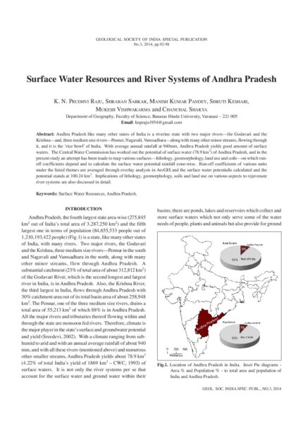
Surface Water Resources and River Systems of Andhra Pradesh
SKU:
C-62885
Andhra Pradesh like many other states of India is a riverine state with two major rivers - the Godavari and the Krishna - and, three medium size rivers - Penner, Nagavali, Vamsadhara - along with many other minor streams, flowing through it, and it is the 'rice bowl' of India. With average annual rainfall at 940mm, Andhra Pradesh yields good amount of surface waters. The Central Water Commission has worked out the potential of surface water (78.9 km3) of Andhra Pradesh, and in the present study an attempt has been made to map various surfaces - lithology, geomorphology, land use and soils - on which runoff coefficients depend and to calculate the surface water potential rainfall zone-wise. Run-off coefficients of various units under the listed themes are averaged through overlay analysis in ArcGIS and the surface water potentialis calculated and the potential stands at 100.24 km3. Implications of lithology, geomorphology, soils and land use on various aspects to rejuvenate river systems are also discussed in detail.

Surface Water Resources of Karnataka – Uncertain Quantum and Stressful Scenario
SKU:
C-62867
The State of Karnataka covers an area of 190498 km2 with a population of 61 million. Geologically, the state is covered by Archaeans, Proterozoic sediments, basalts of Deccan Trap Province and alluvium of Recent age. The Western Ghats, Karnataka Plateau and Coastal Landforms are the major geomorphic features of the state. In spite of seven river systems and 36,753 tanks in Karnataka, 67 percent of the land falls under dry tracts. Estimates are available for the average yield of river basins of the state. The quantum of water available in a water year for utilization appears to be beyond assessment because of erratic behaviour of rainfall and Inter-State River Water disputes. The poor management of catchment area, siltation of water bodies, poor management of distribution network, abuse and misuse of resources are the other factors for the stressful situation. The impact of climate change on the water resources cannot be ignored. To cater to the needs of growing population, the available water has to be protected, improved and managed efficiently. The approach should be holistic including soil specific agricultural practices, judicious use of water and awareness of stressful situation of water resources. Since the Krishna and Cauvery basins are "Closed Basins," the riparian states should have positive approach in the interest of the people.
The Monsoon-Fed Rivers of Maharashtra: Their Hydrogeomorphic Characteristics and Management
SKU:
C-62868
All the rivers of Maharashtra are rainfed. Their annual flow pattern strictly changes in accordance with the monsoon rainfall. The orographic effect of the Western Ghat is mainly responsible for significant spatial variation in the rainfall in the state. Due to the dominance of hard rock terrain (?95%), the availability of groundwater is generally low and there is severe water scarcity in the dry season, particularly in the rainshadow zone. In spite of the fact that irrigation sector in Maharashtra is one of the largest, and long-term trends in monsoon rainfall have revealed significant increase in ten western districts, still a large part of agriculture is rainfed and thousands of villages are dependent on water tankers during the dry season. In recent years greater emphasis has been placed on integrated water resource management approaches for sustainable development. Construction of rainwater harvesting and runoff management structures under watershed development programs as well as measures to influence water user's behavior have achieved only modest success, except in a few isolated cases where local leadership has played a crucial role. As water scarcity in many areas persists and there are serious problems of catchment degradation and pollution, the challenge is to develop better water management strategies and technologies with a focus on sustainable water resources in a scenario of climate change.