
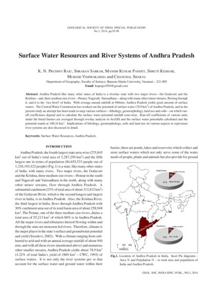
Resource potential in space and time is dependent upon the hydro-geomorphic dynamics that include topography, precipitation and lithology. Regional geo-climatic conditions control the distribution and availability of water resources and their development requires a scientific evaluation of potential and terrain appropriate structures. In this context, the northwestern region of the Indian subcontinent has diverse geomorphologic characteristics ensuring a wide disparity in the distribution of surface water resource. The rivers are seasonal and the flow is dependent on the rainfall which varies from less than 100 mm in the arid land to more than 1000 mm in the eastern hilly areas. Based on the variations in these parameters, the area is divided into five hydro-geomorphic units 1) Dunal Plains of Thar, 2) Semi-arid to Arid Alluvial Plains, 3) The Eastern Hill Ranges, 4) The Plateau and Pediments (buried/exposed) and 5) Coastal Plains. The major issues in harnessing the surface water include seepage/evaporation losses in the plains and excessive runoff due to steep slopes and hard rock lithology in the hilly areas. Unavailability of water in the downstream due to damming of rivers, changing land use and obliteration of drains in the catchment of ponds are some human induced major issues in this region. Ample groundwater resource and advent of tube wells led to neglect of the existing water harvesting structures as well as surface water bodies, but now, the ground water is fast depleting. There is good surface water potential at least in parts of the region, but its rejuvenation needs impetus. The water availability and security can be improved adopting a basin perspective provided the resource is managed in a holistic and integrated manner at this level.

Geomorphology of North-Western India (Marusthali to Narmada Valley Ending Up with Vindhyan Scarplands) with Special Reference to Surface Waters
₹100.00
Resource potential in space and time is dependent upon the hydro-geomorphic dynamics that include topography, precipitation and lithology. Regional geo-climatic conditions control the distribution and availability of water resources and their development requires a scientific evaluation of potential and terrain appropriate structures. In this context, the northwestern region of the Indian subcontinent has diverse geomorphologic characteristics ensuring a wide disparity in the distribution of surface water resource. The rivers are seasonal and the flow is dependent on the rainfall which varies from less than 100 mm in the arid land to more than 1000 mm in the eastern hilly areas. Based on the variations in these parameters, the area is divided into five hydro-geomorphic units 1) Dunal Plains of Thar, 2) Semi-arid to Arid Alluvial Plains, 3) The Eastern Hill Ranges, 4) The Plateau and Pediments (buried/exposed) and 5) Coastal Plains. The major issues in harnessing the surface water include seepage/evaporation losses in the plains and excessive runoff due to steep slopes and hard rock lithology in the hilly areas. Unavailability of water in the downstream due to damming of rivers, changing land use and obliteration of drains in the catchment of ponds are some human induced major issues in this region. Ample groundwater resource and advent of tube wells led to neglect of the existing water harvesting structures as well as surface water bodies, but now, the ground water is fast depleting. There is good surface water potential at least in parts of the region, but its rejuvenation needs impetus. The water availability and security can be improved adopting a basin perspective provided the resource is managed in a holistic and integrated manner at this level.
| Publication Mode |
Online |
|---|---|
| Publication Author |
Alpa Sridhar, L. S. Chamyal |
| Publication Language |
English |
| Publication Type |
Conference Paper |
| Publication Year |
2014 |
Related products
Assessment of Groundwater Pollution Potential of Goa using an Indexing Approach (Abhesht & Galdit Models)
Sustainable Development and Management of Groundwater of Chhattisgarh: An Overview
Surface Water Resources of Chhattisgarh: An Overview
Delineation of Aquifers through Ground Water Exploration in Goa State
Strategies for Ground Water Resources Management to Facilitate Water Security in Gujarat
Water Resources in Goa
Groundwater Resources of Rajasthan: Status, Issues and Strategies
Reviews
There are no reviews yet.