
Publications

Status of Rivers in Tamil Nadu: Problems and Perspectives
SKU:
C-62888
Water is the prime resource responsible for sustaining life in the earth. Water within a river basin has to be properly allocated for various uses like generation of electricity, domestic supply, for irrigation, for industrial use, and in some cases for recreation as well. On par with this is the disposal of domestic waste, effluents and other pollutants forming the other side of the water distribution. To add to these are the vagaries of monsoon affecting the basin by extreme drought or flood. Rivers of Tamil Nadu can be grouped into 17 river basins (127 sub-basins) a majority of which are water-stressed. The average annual rainfall is 950 mm with bimodal distribution. Water Balance equation is the general term used to describe the flow of water in and out of a river system. It is illustrated using a water balance graph which plots the precipitation, evapotranspiration on a month wiseinterval. Classification of river basins into surplus basins and deficit basins is the prime requirement for allocation of water in various sectors and exchange of water from surplus basins to the deficit basins. This paper highlights the ways and means to restore, revive and replenish the available water resource in a judicial manner. To some extent the location and nature of surface water bodies (rivers, lakes, tanks, and reservoirs) are controlled by the geology and geomorphology (land forms) of the area and some data is provided on this aspect as well of the study area.
Status of Surface Water Resources of Kerala ? Development and Management Issues, Future Strategies
SKU:
C-165439
Kerala State is a narrow strip of land situated on the south-west coast of India with the Western Ghats as its eastern boundary. The State experiences a humid tropical climate and receives an average annual rainfall of 3000 mm, which feeds all the water bodies in the State. Rising population, urbanization, industrialization, changing life style of people, etc. is increasing the freshwater demand in Kerala every year. Water management in Kerala is a difficult task due to high spatial and temporal rainfall variations, undulating topography with steep slope towards sea, high population density, lengthy coastal stretch with saline backwaters and estuaries, climate change, etc. The State faces recurring floods and droughts, pollution in freshwater bodies, salinity intrusion/ingress in rivers and coastal aquifers, etc. In the context of spatial and temporal variations in water availability, increasing water pollution and the steady increase in water demand over the years, the State should have scientific water conservation and management strategies aimed at the improvement of surface water and groundwater availability, mitigation of flooding during monsoon, prevention of water pollution and improvement of the water quality, improvement of water use efficiency, prevention of unscientific land use changes, creation of water awareness, rainwater harvesting and also the wise and efficient use of freshwater resources, etc. Status of surface water resources of Kerala, its development and management issues and future management strategies are presented here.


Strategies for Ground Water Resources Management to Facilitate Water Security in Gujarat
Conference Papers, SP-12: Water Resources of Western and Central Regions of India: Status, Issues and Strategies
SKU:
C-168756
As per the assessment of the dynamic ground water resource in Gujarat the utilsable ground water resources have been assessed as 24905 MCM, after providing for natural discharge (March 2021). The annual ground water draft is 13296 MCM. The Stage of ground water development works out to be about 53%. However, this is not uniform across the state. The stage of development is exceedingly high in North Gujarat and Kachchh regions. Highly intensive development of ground water in these areas has resulted in over - exploitation leading to the decline of ground water levels, deterioration in the ground water quality and sea water intrusion in the coastal areas. The paper presents existing scenario of various supply and demand side interventions implemented in the state with their impact. Recommendations for various interventions necessary for sustainable ground water management have been made with particular emphasis on use of scientific inputs from the supply as well as demand side interventions to the community participation in planning, implementing and monitoring.
Stratigraphy and Depositional Environment of Sediments of the Goradongar Formation, Goradongar Range, Patcham Island, Kachchh
SKU:
C-105407
The Middle Jurassic (Bathonian-Callovian) rocks of the Goradongar Formation of the Goradongar range ~144.4 m thick succession constitutes of Goradongar Flagstone, Gadaputa Sandstone, Raimalro Limestone and Modar Hill members in an ascending order. The successions contain variable thick bands of pure clastic (arenaceous), non-clastic (allochemic limestone), mixed siliciclastic-carbonate rocks, shales and intraformational conglomerates. Mixed siliciclastic-carbonate sediments dominate the succession which are further classified according to their compositional variation and identified as micritic sandstone, allochemic sandstone, sandy allochem limestone, micritic mudrock and sandy micritic. The mixed siliciclastic-carbonate succession of the formation is intercalated by shales; and at certain stratigraphic levels it becomes pure clastic or non-clastic. The nonclastic successions are further analysed for microfacies which includes pelloidal grainstone, bioclastic grainstone, bioclastic packstone, pelloidal packstone and oolitic packstone. These rock units are characterized by sedimentary structures such as planar laminations, cross bedding and ripple (wave and current) marks; while certain bands are highly fossiliferous and bioturbated which display change in depositional regime. Variation in sediment composition, textural immaturity, and associated sedimentary structures of the Goradongar succession indicate the fluctuations in rate of sediment supply, energy levels and bathymetric conditions; and suggest two depositional regimes: lower shoreface to offshore transition and offshore.

Strontium Isotope Stratigraphy of the Naredi Formation, Kutch Basin, India
SKU:
C-63304
The Naredi Formation records the first marine transgression of the Cenozoic era in Kutch. Its age has remained equivocal and various workers have assigned different ages ranging from Late Palaeocene to Early and Middle Eocene. In this study we carried out strontium isotopic analysis of the foraminiferal shells of the Naredi Formation to determine its numerical age in order to resolve this controversy. The measured 87Sr/86Sr ratios, lying between 0.707727 and 0.707816, have been compared with the standard strontium isotope variation curve for the Cenozoic. Biostratigraphically, the formation ranges from shallow benthic zone SBZ 6 to SBZ 11 corresponding to planktonic foraminiferal zones P5 to P9 (Serra-Kiel et al., 1998). The biostratigraphically constrained Sr isotopic values indicate that the Naredi Formation is of Early Eocene age spanning from 50 to 55Ma.
Study of Wax Inhibition in the Indian Waxy Crude Oil by Polarizing Microscope and its Effect on Rheology
SKU:
C-95906
This research article deals with the effect of thermal conditions on the size and morphology of waxy crystals in the Indian crude oil and their influence on the rheological property at different temperatures. The effect of concentrations of flow improvers on the rheology of waxy crude oil has also been studied. Two commercial pour point depressants are used to show the effect of additives on waxy crude oils.The images of wax crystals are taken at various temperatures for both virgin and additivetreated crude oil. Both temperature and additive treatment affect the size and morphology of crystals. Wax crystals have little influence on the rheological properties of the oil at high temperature because the sample is a dilute suspension at this temperature. As the sample was cooled to lower temperature, more wax crystals appeared, with very little agglomeration at first. These crystals were also increasing in size. Due to the wax crystals, the oil acts as a dispersive suspension. Agglomeration between particles becomes common and a lattice is formed and all neighboring agglomerates appear to be connected to each other. The network between wax crystals can be more clearly observed at lower temperatures. The waxy structure at this temperature is more likely to be a porous medium with a continuous phase of solid wax and a dispersed phase of oil base. In case of additivetreated crude oil, wax crystals do not agglomerate even at lower temperatures, which shows that treated crude oils are both pumpable and flowable at even low temperatures which is not the case in neat crude oil. Also, from rheological studies it is shown that additive-treated crude oil require less shear stress i.e less power consumption for transportation.
Study on Spectral Signature of Kaolinite {Al2Si2O5(OH)4} from Bageshpura Clay Mines, Hassan District of Karnataka
SKU:
C-95910
Hyperspectral remote sensing is an advanced and up-coming technology in the field of remote sensing. The Geological Survey of India (GSI) has taken a lead in building up a comprehensive spectral library for rocks and minerals for the entire Indian sub-continent in line with the spectral library of the United States Geological Survey (USGS) and the Jet Propulsion Laboratory (JPL). The readymade spectra of minerals (including ore minerals) and rocks (altered and unaltered) could help in the identification of the mineralogical composition of an unknown area and ultimately in targeting the mineralised zones. The study is aimed at the spectral signature of kaolinite in both the solar illumination in the field and in artificial illumination (tungsten quartz halogen lamp) as source in the laboratory condition. The diagnostic absorption features of kaolinite in visible and NIR wavelrngh (0.35-2.50 ?m) are unavailable in the conventional remotely sensed data specially at 1.40 ?m and 1.90 ?m because of atmospheric obscuration. Kaolinite shows intense absorption at 1.396, 1.413, 1.913, 2.166 and 2.209 ?m and comparatively less absorption features at 0.37, 0.97, 2.327, 2.356, 2.385 ?m. The slightly broad absorption feature at 1.396 ?m with a sharper band at 1.413 ?m is because of the OH stretch overtones and features at 2.166 and 2.209 ?m are because of Al- OH bend plus OH stretch combination. Doublet at 1.40 and 2.20?m is characteristic of kaolinite.
Subsurface Coal Fire Mapping in Patherdih Colliery, a Part of the Jharia Coal Field, India
SKU:
C-95899
Coal fires are a universal problem in worldwide coal mining areas. They burn out precious coal resources, hinder mining activities and pose a danger to man and machine, besides leading to environmental pollution and land subsidence problems. In this context, high resolution magnetic survey offers a powerful tool for the detection, delineation and monitoring of coalfires. The Jharia coalfield in India is known for its high grade coal and associated coal fires. The valuable coal reserves are destroyed in the subsurface due to fire, before their exploitation. The present study deals with the mapping and understanding of subsurface coal fire on the basis of magnetic properties of materials and their changes with temperatures above or below the Curie temperature. The coal burning heat rising above Curie temperature results in a loss of natural magnetism in nearby area. Small regions, called domains, within the crystal structure reorient themselves which upon cooling; align themselves more or less in the direction of the ambient magnetic field. This remanent magnetism may be several orders of magnitude greater than the natural magnetism. The minerals which are formed and their respective magnetic strengths depend on the temperatures reached and the amount of oxygen available. Magnetic data acquisition has been carried out using high resolution GSM-19T proton precession magnetometer in gradient mode. The acquired magnetic data have been processed and analyzed using Geosoft Oasis Montaj software to study magnetic field anomaly of Patherdih Colliery in Jharia coal field, India for mapping and understanding of subsurface coal fire. The processed data provide a clear indication of location of active coal fire affected area. This repeated study could help for characterization of dynamics of coal fire of the region.
Surface and Ground Water Resources of Maharashtra: Status, Management, Governance Issues, and Future Policy
Conference Papers, SP-12: Water Resources of Western and Central Regions of India: Status, Issues and Strategies
SKU:
C-168751
Air, Solar energy, Land, and Water are the four life support systems of which, only ?Water? is amenable for its development and management to meet human needs of water. Water Resource Development structures had to be compatible to the characteristics of ?Water Resource?. With the advancement of civilization, ingenuity of man prompted him to evolve different types and sizes of infrastructure to meet changing patterns and increasing magnitude of water demand. It also stressed the need to have an integrated approach in such development. Subsequently as a soft option, improvement in management of infrastructure was the next logical step. As the issue of complexities in the competing and conflicting demands on water surfaced prominently, need for taking a holistic approach towards them was thought of and there emerged the viable solution in the form of better governance of water resources. An attempt has been made here in below to present evolution of all these developments by citing a case study of Maharashtra State in the Peninsular India. It mentions at the end a ?Vision Statement? for the future development of the State in the water sector and an outline of future planning and policies which need to be adopted. In conclusion it states a framework of desirable actions to be taken in future, to transform the ?Vision? into a reality.
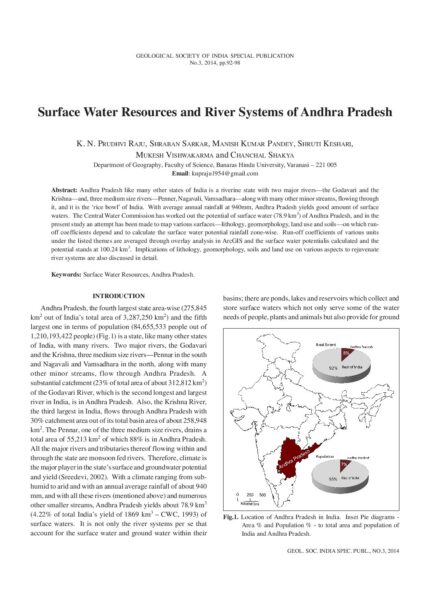
Surface Water Resources and River Systems of Andhra Pradesh
SKU:
C-62885
Andhra Pradesh like many other states of India is a riverine state with two major rivers - the Godavari and the Krishna - and, three medium size rivers - Penner, Nagavali, Vamsadhara - along with many other minor streams, flowing through it, and it is the 'rice bowl' of India. With average annual rainfall at 940mm, Andhra Pradesh yields good amount of surface waters. The Central Water Commission has worked out the potential of surface water (78.9 km3) of Andhra Pradesh, and in the present study an attempt has been made to map various surfaces - lithology, geomorphology, land use and soils - on which runoff coefficients depend and to calculate the surface water potential rainfall zone-wise. Run-off coefficients of various units under the listed themes are averaged through overlay analysis in ArcGIS and the surface water potentialis calculated and the potential stands at 100.24 km3. Implications of lithology, geomorphology, soils and land use on various aspects to rejuvenate river systems are also discussed in detail.
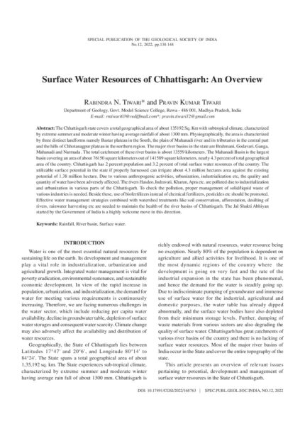
Surface Water Resources of Chhattisgarh: An Overview
Conference Papers, SP-12: Water Resources of Western and Central Regions of India: Status, Issues and Strategies
SKU:
C-168763
The Chhattisgarh state covers a total geographical area of about 135192 Sq. Km with subtropical climate, characterized by extreme summer and moderate winter having average rainfall of about 1300 mm. Physiographically, the area is characterized by three distinct landforms namely Bastar plateau in the South, the plain of Mahanadi river and its tributaries in the central part and the hills of Chhotanagpur plateau in the northern region. The major river basins in the state are Brahmani, Godavari, Ganga, Mahanadi and Narmada . The total catchment of these river basins is about 13559 kilometers. The Mahanadi Basin is the largest basin covering an area of about 76150 square kilometers out of 141589 square kilometers, nearly 4.3 percent of total geographical area of the country. Chhattisgarh has 2 percent population and 3.2 percent of total surface water resources of the country. The utilizable surface potential in the state if properly harnessed can irrigate about 4.3 million hectares area against the existing potential of 1.38 million hectare. Due to various anthropogenic activities, urbanization, industrialization etc, the quality and quantity of water have been adversely affected. The rivers Hasdeo, Indravati, Kharun, Apra etc. are polluted due to industrialization and urbanization in various parts of the Chhattisgarh. To check the pollution, proper management of solid/liquid waste of various industries is needed. Beside these, use of biofertilizers instead of chemical fertilizers, pesticides etc should be promoted. Effective water management strategies combined with watershed treatments like soil conservation, afforestation, desilting of rivers, rainwater harvesting etc are needed to maintain the health of the river basins of Chhattisgarh. The Jal Shakti Abhiyan started by the Government of India is a highly welcome move in this direction.

Surface Water Resources of Karnataka – Uncertain Quantum and Stressful Scenario
SKU:
C-62867
The State of Karnataka covers an area of 190498 km2 with a population of 61 million. Geologically, the state is covered by Archaeans, Proterozoic sediments, basalts of Deccan Trap Province and alluvium of Recent age. The Western Ghats, Karnataka Plateau and Coastal Landforms are the major geomorphic features of the state. In spite of seven river systems and 36,753 tanks in Karnataka, 67 percent of the land falls under dry tracts. Estimates are available for the average yield of river basins of the state. The quantum of water available in a water year for utilization appears to be beyond assessment because of erratic behaviour of rainfall and Inter-State River Water disputes. The poor management of catchment area, siltation of water bodies, poor management of distribution network, abuse and misuse of resources are the other factors for the stressful situation. The impact of climate change on the water resources cannot be ignored. To cater to the needs of growing population, the available water has to be protected, improved and managed efficiently. The approach should be holistic including soil specific agricultural practices, judicious use of water and awareness of stressful situation of water resources. Since the Krishna and Cauvery basins are "Closed Basins," the riparian states should have positive approach in the interest of the people.
Surface Water Resources of Kerala: Key Policy Issues and Management Strategies
SKU:
C-165448
Though the tiny state of Kerala in South India appears to be extraordinarily rich in water resources, there are several challenges associated with its sustainable management. Recent occurrences of extreme climatic events in the form of heavy rainfall over noticeably short periods, signify the urgent need for Integrated Water Resource Management (IWRM) in the state. Revisiting the state water policy in this context needs wider consultations and more meaningful deliberations. Along with a broad overview of the surface water potential of the state, this paper discusses some of the important concerns that are to be addressed with adequate policy responses. Pollution abatement, ensuring adequate environmental flows in the river basins, having the Water Resources Information System (WRIS) in place, revisiting its interstate water sharing pacts, grooming the real time integrated operation of its reservoirs, and rolling out conjunctive water management plans are all vital. Equally vital are the plans to improve water conservation, propagating community micro irrigation systems and adopting climate resilient cropping. Setting up the appropriate institutional arrangements and enabling the environment for IWRM must be crucial for the state in this perspective.
Surface Water Resources of Madhya Pradesh: An Overview
Conference Papers, SP-12: Water Resources of Western and Central Regions of India: Status, Issues and Strategies
SKU:
C-168761
Madhya Pradesh is endowed with sufficient surface water. This water is available to the state thorough perennial rivers Narmada, Son, Tapti, Chambal, and Wainganga. These rivers also have numerous perennial tributaries. The total surface water availability in the Chambal, Betawa, Ken catchment is 45 cubic km; 29.29 cubic km in the Son catchment; 52.43 cubic km in the Mahanadi river catchment; 40.83 cubic km in the Narmada catchment and 4.53 cubic km in Wainganga and Pench catchment. Madhya Pradesh received erratic precipitation during the last five years . So it does not have sufficient surface water. The need is for proper management of available surface water resources including systematic monitoring and water conservation techniques. Involvement of Panchayats and other stakeholders is essential to augment surface water bodies through tanks and other rainwater impounding structures. It is time that the stake holders should be aware of the availability of resources for future use, and benefits of conjunctive use of surface and groundwater.
Surface Water Resources of Maharashtra: Potential, Development and Management Issues
Conference Papers, SP-12: Water Resources of Western and Central Regions of India: Status, Issues and Strategies
SKU:
C-168752
The water sector in Maharashtra is facing critical challenges. First, uneven availability of water over space and time is the biggest challenge and secondly, dramatically increasing competing demands for water from different sectors are giving rise todisputes and conflicts. Of the total water used in the state, about 82% goes to irrigation, 12% for domestic water supplies, 4% forindustrial use, and the remaining for other uses such as livestock, hydro and thermal power generation. With the urban population of about 51 million (45%), and rapidly growing urban centres and industries, there is considerable gap in demand and supply of thestate's scarce water resources. This has posed serious challenges to water security. There can be only limited dependence upon the groundwater resources for the protective irrigation in the State as 85% area is Deccan basalt having limited ground water recharge potential. Also access to safe drinking and other domestics is a challenge in the rural areas of the State. Planning and Management of water resources in a coordinated and holistic manner is needed. Considering the scarcity of water in large part of Maharashtra and substantial utilisation by irrigation sector, there is a need to expedite measures for improving Water Use Efficiency (WUE) so that water saved in irrigation can be utilised for other non-irrigation purposes. The paper gives an overview of the water resources scenario in Maharashtra with reference to surface water and discusses various water management issues that need focused attention. The paper brings out the impact of decision of various water dispute tribunals on the water availability for the State and also the need for inter-basin and intra-basin water transfer. It emphasises the need for upscaling use of Micro Irrigation (MI), Pipe distribution system, large scale integrated MI systems throughout the State etc. for not only to save substantial amount of water but also to help in increase the productivity and quality of agriculture produce. The paper also touches upon the issues of water quality and flood management in the State.

Surface Water Scenario in Rajasthan State, India
Conference Papers, SP-12: Water Resources of Western and Central Regions of India: Status, Issues and Strategies
SKU:
C-168758
Surface water resources in Rajasthan are scarce and scanty owing to hot arid climatic conditions. Major parts of western Rajasthan are devoid of any major drainage system and are reeled under spells of chronic droughts. Average annual rainfall in the state is of the tune of 540mm, decreases westward and is even less than 150mm in the western most parts of Jaisalmer district. Annual Potential evapo-transpiration is also as high as 2060mm in parts of Jaisalmer district. There are 15 river basins in the state. There are also numerous natural as well as artificial freshwater lakes including Pushkar, Rajsamand, Nakki, Ana Sagar, Kayalana, Ramgarh, Foy Sagar etc. mainly in the southern and eastern parts of the state. Salt lakes include Sambhar, Kuchaman, Pachpadra, Didwana, Phalodi, Lunkaransar etc. Indira Gandhi Nahar (IGNP), Bhakara and Gang canals have been constructed to bring Himalayan water to the desert areas of western Rajasthan in addition to other major commands of Chambal, Mahi and Narmada canals etc. In Rajasthan, irrigation projects completed include 22 Major projects, 77 Medium projects, 660 Minor projects and 3139 Tanks have been transferred to Panchyat Raj Department. Usable water is of the magnitude of 16.05 BCM and the Gross Storage Capacity created is of the order of 14.547 BCM. The Live Storage Capacity created is about 11.99 BCM. Out of the total allocated share of 17.88 BCM under interstate water agreement, average annual water availability remains 12.66 BCM due to various climatic, political, institutional or hydrological reasons. In addition to various Central Government Schemes, Watershed schemes and Mukhyamantri Jal Swavlamban Abhiyan are also implemented in the state.
Sustainable Development and Management of Groundwater of Chhattisgarh: An Overview
Conference Papers, SP-12: Water Resources of Western and Central Regions of India: Status, Issues and Strategies
SKU:
C-168765
In general, Chhattisgarh state is underlain by hard rocks with limited groundwater potentials. But decline of rainfall in most parts of the state is limiting surface water resources too. Agriculture is mostly rainfed, paddy being the main crop in the state. Groundwater is the main source of irrigation and a major source of drinking water. Cavernous limestones/dolomites form the most potential aquifers yielding up to 50 lps as in Bastar, Baloda Bazar and Bilaspur districts. Proposal for construction of energized irrigation dug/bore wells under PMKSY-HKKP-GW scheme in 109 blocks (stage of extraction within 60%) of 7 aspirational districts will enhance ground water irrigation of 7467 ha land. The stage of extraction has already escalated from 5.11% (1990) to 44.43% (2017) which will be escalated further with ongoing and future development programs. The State should undertake conservation of groundwater through regulation, protection and augmentation of the water resources by implementing rainwater harvesting and artificial recharge, along with adoption of rainfed agriculture, drip or sprinkler irrigation, pricing policy for commercial ground water extraction, exploration and planned development of yet unknown aquifers through exploratory drilling aided by remote sensing, geophysics . Based on declining groundwater level trends areas totalling 16,410 sq. km have been demarcated for rainwater harvesting and artificial recharge creating sub-surface ground water storage potential of 1030.11 MCM and an additional irrigation potential of 148430 ha. Further, groundwater pollution from geogenic and anthropogenic sources like high fluoride, arsenic, uranium, sulphate, nitrate as in Rajnandgaon, Durg, Bilaspur, Raipur and Kwardha districts is also a potential threat to the utilisable resources.This paper attempts at a holistic overview of sustainable development and management of ground water resources of the state considering the huge hydrogeological, geophysical and chemical database in the state.

Sustainable Water Management in Lakshadweep Islands: An Integrated Approach
SKU:
C-95962
Fresh water management in small islands is a delicate issue as the available resources are limited. The fresh water lenses in these islands are in equilibrium with the seawater and are affected by diurnal and seasonal tidal effects. Shape of the islands influence stability of the freshwater lens and the water quality variations in response to tides are significant. Lakshadweep islands are tiny coral islands with a fragile hydrogeological environment. Groundwater potential of these tiny islands cannot be assessed based on water table fluctuation. Water budgeting seems to be the most accurate and the recharge were assessed accordingly, separately for brackish and freshwater lens areas. An integrated water management approach involving rainwater harvesting, desalination of seawater and sustainable development of freshwater lenses are explored and the technical viabilities of such approaches are ascertained.
Targeting Groundwater in Hard Rocks of Odisha: Aeromagnetic Surveys
SKU:
C-164719
Interpretation of satellite imagery only helps partially since many structures may not have a surface expression as they are likely to be obscured by covering of soil/ vegetation and hence, effective mostly in areas with rock exposures. On the contrary, groundwater is generally needed in comparatively flat areas with soil cover. Ground based geophysical methods have slow coverage and are expensive. Airborne survey data helps in narrowing down the areas for ground-based methods. To resort to the latest technology of airborne geophysical survey for groundwater targeting in the hard rock crystalline terrain of the state, Government of Odisha took up the ?Orissa Groundwater Project? in collaboration with the Government of Western Australia. The project was jointly carried out by the Directorate of Geology, Odisha and World Geoscience Corporation, Perth, Western Australia, which undertook the Survey.The High Resolution Aeromagnetic Survey was conducted over 75,000 sq km area of the hard rock terrain in Odisha covering 109 Survey of India toposheets of 1:50,000 scale. Various types of data and information like Total Magnetic Intensity, 256 Channel Radiometric Data (windowed for Gamma Ray radiations of K, Th & U) and Digital Elevation Model were acquired by flying at a low altitude of 80m for higher resolution. The datasets were processed, imaged and interpreted to prepare Geological and Hydrogeology target maps with support of necessary fieldwork. Interpretation of airborne data ensured incorporation of continuous geological information in these maps irrespective of the surface covers. The purpose of the Hydrogeological Target Map series is to show the known hydrogeological conditions and related data to outline zones which are considered by current knowledge to have good potential to produce groundwater.
Tectonic Framework, Structure and Tectonic Evolution of Kutch Basin, Western India
SKU:
C-105417
The Kutch basin is a western margin pericratonic Mesozoic rift basin. The rift basin originated during break up of Eastern Gondwanaland. The rift basin is bound by Nagar Parkar uplift on the north and Kathiawar uplift (Saurashtra horst) on the south respectively along Nagar Parkar and North Kathiawar faults (NPF&NKF). The rift is styled by three main uplifts along three master faults, (from north to south) Island Belt, Kutch Mainland and Wagad uplifts, with intervening grabens and half-grabens. The uplifts are upthrust basement blocks tilted along sub-vertical faults with initial normal separation. The NKF is the principal master fault along which the rift subsided most. The structure is thus styled by tilted blocks and half-grabens within a south tilted asymmetric rift basin. Blanketing carapace of sediment over the basement drape folded over the tilted edges of the basement blocks as marginal flexures. The flexures are knee-bend folds with narrow deformation zones along the crest. The deformation zone encloses complicated folds, locally much faulted and intruded by igneous rocks. In the western part the uplifts are tilted to the south with flexures draped over the faulted up northern edges. In the eastern part a large uplift, Wagad Uplift, occurs between the Mainland and Island Belt uplifts. It is tilted towards the north along the South Wagad Fault (SWF), opposite to other uplifts, with a narrow deformation zone along the faulted up southern edge. The back slope ends up against Bela horst of the Island Belt uplift along Gedi Fault.A subsurface basement ridge - Median High, crosses the basin in the middle at right angle to its axis. Acting as a hinge it divides the basin into a deeper western part and a shallower and more tectonised eastern part. The rift is terminated in the east against a transverse subsurface basement ridge, Radhanpur-Barmer Ridge, which is the western shoulder of the adjacent N-S oriented Cambay rift. To the west, the rift merges with offshore shelf.The Kutch basin is the earliest pericratonic rift basin to form in the western volcanic passive margin of the Indian craton during the Late Triassic break up of Gondwanaland. The rift evolution with syn-rift sedimentation continued through Jurassic till Early Cretaceous as Indian plate separated from Africa and drifted northward. The rift expanded from north to south by successive reactivation of primordial faults of Mid-Proterozoic Delhi fold belt. The faults strike E-W but eastward the strike swings to NE-SW merging with the Delhi- Aravalli strike.The rifting was aborted by the trailing edge uplift during Late Cretaceous pre-collision stage of the Indian plate. The uplift caused structural inversion during rift-drift transition stage when most of the uplifts with drape folding over the edges came into existence by upthrusting along the master faults. The motion during the drift stage of the plate induced horizontal stress and the near vertical normal faults, which were reactivated as reverse faults during initiation of inversion cycle, became strike-slip faults involving divergent oblique-slip movements.The present structural style evolved by right lateral slip, which shifted the uplifts progressively eastward relative to each other from south to north. This resulted in the present en echelon positioning of the uplifts with respect to Kutch Mainland uplift. The strike slip related structuring modified the linear flexures breaking them into individual folds at the restraining and releasing bends. Narrow deformation zones are complicated by conjugate reidel faults formed along the master faults modifying the initial drape folds. Upward migration of basement faults through ductile sediment drape and the accompanying fault propagated folds further complicated flexural deformation zone. Syntectonic intrusions modified the shape of the structures. The structure of the SWF deformation zone demonstrate a typical strike-slip fault related structural style with two intertwining faults and related folds.Igneous rocks extensively intruded the Mesozoic sediments. Synrift plutonic activity and post rift hotspot related Deccan volcanism are two major magmatic events. Studies on the intrusive bodies and seismological data suggest the presence of an ultramafic magmatic body close to the crust-mantle boundary. This suggests mantle stretching, thinning and rupturing during rifting which led to deep crustal melting and formation of magma that intruded during inversion stage.
Terminal Maastrichtian Age Calcareous Nannofossils Preceding K/T Mass Extinction from Aladi Formation, Vridhachalam Area, South India
SKU:
C-63314
A moderately diversified, well preserved, low frequency nannofossil assemblage with over twenty species is recorded from one (S-13) calcareous marl sample of the Ariyalur Formation situated north of the village Aladi. The assemblage includes the latest Maastrichtian index species Micula prinsii. Preservation is good and although specimens are overgrown, no dissolution effects are apparent. The assemblage is of late Maastrichtian age CC 26b (Perch-Nielsen, 1985) correlative with UC 20dTP (Burnett, 1998). The range of Micula prinsii, a low latitude marker, is indicative of the latest Maastrichtian magnetochron C29r below the K/T boundary that spans approximately the last 500,000 years of the Maastrichtian. In addition, high abundance of Petrobrasiella? bownii in both very small and large sizes (3-4 ?m to 10 im diameter) along with Ceratolithoides aculeus, C. kamptneri, Arkhangelskiella maastrichtiana, Calculites obscurus attests to this zonal placement. The high latitude Maastrichtian genus Nephrolithus, represented by N. miniporus, is also present in the assemblage and indicates a cold water current in the southeastern part of India during latest Maastrichtian. Reworked Campanian species represented by Nannoconnus spp. and Haqius circumradiatus are also present in the assemblage. Further study of this locality may provide a record of the K/T boundary.

The Indigenous Knowledge Systems of Water Management in India
SKU:
C-95943
The traditional knowledge systems of water management have served the communities to withstand the scourge of drought, including drinking water crisis. Johads are the most popular water harvesting structures, historically in use in Rajasthan, but rendered defunct through non maintenance and neglect. Tarun Bharat Sangh (TBS), an NGO in Rajasthan, has mobilized the community to undertake revival of this traditional knowledge system through restoration of the defunct water harvesting structures and construction of the new ones in Alwar district, Rajasthan. This pioneering endeavor yielded spectacular cascading effects on environment, ecology and socioeconomy apart from revival of the dead river Arvari. TBS has established that our traditional ecofriendly knowledge system of water management is still relevant in the country.