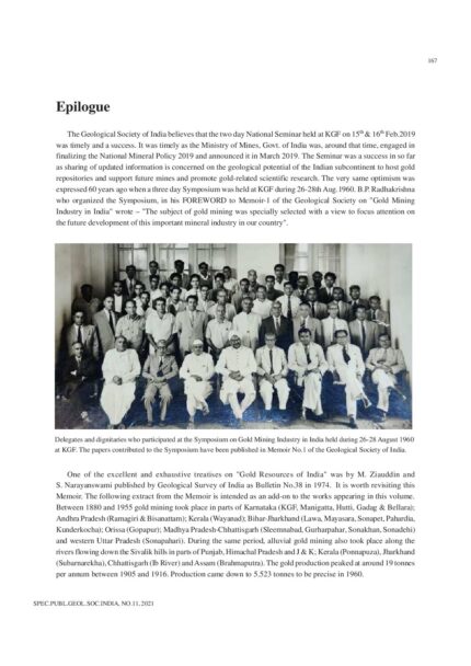
Publications

Development of Emulsion Based Drilling Fluid System for Depleted Fractured Reservoirs
SKU:
C-95907
Oil-in-water (O/W) emulsion drilling fluid is one of the most important low-density drilling fluids suitable for depleted fractured reservoirs for avoiding formation damage during oil and gas well drilling. In this work, an attempt has been made to study the rheological and filtration properties of oil-in-water emulsion drilling fluids containing guar gum as viscosifier and calcium carbonate as filtration controlling agent. Test results have shown that guar gum shows vicosifying properties for oil-inwater emulsion drilling fluids (diesel oil as dispersed phase and KCl brine as continuous phase). The stability of the emulsion systems was well achieved by an anionic, water soluble and biodegradable surfactant. The filtrate loss was mainly controlled by CaCO3.. The filter cakes formed were thin, impermeable and the volumes of filtrate obtained were within the limits reported in literatures. Drilling fluid combinations were developed by varying concentration of guar gum and CaCO3 to examine the effect of these additives on emulsion and these combinations have shown favourable rheological and filtration properties up to 70?C; these can be used for the better drilling performance in depleted fractured reservoirs.
Development of Non-Damaging Drilling Fluid System for Shale Gas Reservoirs
SKU:
C-95908
Unlike conventional reservoirs, drilling and completion program for shale gas reservoirs need high technical expertise and vast experience. Drilling of shale formations poses high challenge to drilling engineers due to the presence of different clay minerals which lead to swelling of the shale formations when interaction with drilling fluid occurs. Hence, an attempt is made to develop a non-damaging drilling fluid which can drill the shale formations effectively and safely. In this work a non-damaging drilling fluid system is developed with the use of different polymers. The developed system contains xanthan gum, pre-gelatinized starch, polyanionic cellulose and calcium carbonate and it is inhibited by potassium chloride salt. An extensive experimental analysis has been carried out with these polymers in order to have optimal rheological and filtration properties. Fann viscometer model 35SA is used to perform rheological studies and Fann API filter press is used to optimize filtration properties. The experimental investigation brings out that the developed drilling fluids have favorable rheological and filtration properties and can be used to drill the shale gas reservoirs without raising any environmental issues.
Discovery of a Kimberlite Pipe-TK6 by Magnetics in the Timmasamudram Cluster, Anantapur District, Andhra Pradesh
SKU:
C-95900
Systematic ground magnetic (total field) investigation in the Timmasamudram-Mauktikapuram block has led to the discovery of a Kimberlite Pipe (TK6) in the Timmasamudram Cluster, Anantapur district, Andhra Pradesh. The Timmasamudram cluster hosts five kimberlite pipes viz., TK1, TK2, TK3, TK4 and TK5. Kimberlite pipe TK1 is signified by prominent bipolar anomaly while TK5 is associated with a low magnetic anomaly. The response over pipe TK2 is in the form of a magnetic gradient while TK3 is associated with strong east-west linear trend. A feeble magnetic anomaly corresponds with the TK4 pipe.The magnetic image map of the block reflects a number of magnetic linear zones that correspond to concealed / exposed dolerite dykes trending in NW-SE, ENE-WSW and NE-SW directions emplaced along fractures / shear zones. The intersections of these magnetic linear trends have been examined by closely spaced magnetic survey, as these zones are promising loci for kimberlite emplacement. The pipe TK6 is identified in one of the intersection of ENE-WSW and NW-SE magnetic linear trends. The pipe TK6 is capped by one metre thick soil cover and pitting over the area indicates boulders of kimberlite in a sole-shaped form over 14 m x 6 m dimension. It needs to be further tested for the occurrence of diamond.
Distribution of Benthic Ostracoda in Surface and Subsurface Backwater Sediments of Ernakulam, Kerala, Southwest Coast of India: Microenvironmental Implications
SKU:
C-63297
Fourteen surface and two core sediment samples were collected from the backwaters of Cochin, Kerala, southwest coast of India, in order to study the systematics and distribution of Recent Ostracoda. The ostracod taxa were separated from the sediments applying standard micropaleontological techniques. A total of 20 Ostracod species belonging to 17 genera and 8 families were identified. Sediment parameters such as CaCO3, organic matter and sand-silt-clay ratio were estimated for the surface as well as core samples in order to determine the relationship between substrate and Ostracoda populations, and to evaluate the favoured substrate of dominant species populations. The down core distribution of sediment parameters and ostracod assemblages is presented. Based on this data we determine that ostracods favour silty-sandy substrate environments. The rate of sedimentation was determined based on the ratio between the carapace and open valves of Ostracoda. The benthic ostracod fauna recorded is characteristic of a tropical, brackish to epi-neritic environment and few warm, shallow marine species occur in the backwaters of Cochin, may be due to the tidal influence.
Distribution of Recent Benthic Ostracoda off Rameswaram, Palk Strait, Tamil Nadu, South East Coast of India
SKU:
C-63296
An investigation to record spatial and seasonal distribution of recent benthic ostracoda was carried out along two transects (East and Northeast) off Rameswaram island of Tamil Nadu coast, India. Thirty sediment and bottom water samples were collected during January 2011 and April 2011 and analysed for various physico-chemical and sediment characteristics using standard procedures. The top 4 cm sediment was preserved in 10% formaldehyde and later in the laboratory the live and total population of Ostracoda was determined using the rose Bengal stain technique. Faunal frequencies for benthic ostracods were computed and correlated with physico-chemical and sediment characteristics. The correlation reveals that ostracod frequency has a positive correlation with sandy substrate and negative correlation with clay substrate and OM%. Faunal frequencies increased by 3 times during summer (April 2011) although values of physico-chemical and sediment characteristics do not show considerable variation from January 2011. The east transect is proximal to the coral reef and characterized by sandy substrate in both seasons, supports high populations and therefore is more congenial for ostracod proliferation. Finally, environmental variables have been correlated with those measured three decades ago to understand the causes for variations.
Drinking Water in Odisha: Resource, Status and Future Strategies
SKU:
C-164717
The state of Odisha is spread over an area of 155707 square kilometres on the eastern coast of India which is 4.74 percent of the land area of the country. It has coastline of 480 kilometres along the Bay of Bengal. The state receives a long term average annual rainfall of 1452 mm compared with the national average of 300 - 650 mm. There are 8 major river basins covering the entire state. Drinking water supply in the urban areas of the state is mostly from surface water and in rural areas it is mostly from ground water. The status of the surface and ground water resources of the state has been discussed as per the data available from the department of water resource (DOWR) and the Central Ground Water Board (CGWB). The available data indicate to a very severe water stress situation in the year 2051. The ground water resource of the state is discussed in the light of the available data. As on 2013 the net ground water availability is 16.69 BCM, the annual draft 5.02 BCM. The stage of development is 30 percent. The drinking water supply in the urban and rural areas of the state is discussed. The domestic demand, and industrial demand of surface water in the year 2051 appears to exceed the dependable flow in all the major river basins of the state. Various strategies to conserve and augment the water resources for an optimum management keeping in mind the effects of climate change are enumerated. The important aspects of the Odisha Water Policy (2007) find mention in the paper.
Early Paleocene Planktic Foraminifers and Stratigraphy, Jaisalmer Basin, Rajasthan
SKU:
C-63307
Early Paleocene planktic foraminifera (Zones P1c to P4) from well sections (Sanu, Sam, Tanot, Ram-1, GTF-1) are reported from the Jaisalmer Basin. The Subzone P1c is characterized by the hemipelagic early Danian species Globoconusa daubjergensis, Eoglobigerina edita, Praemurica pseudoinconstans, P. inconstans, Parasubbotina pseudobulloides, Subbotina triloculinoides and Globanomalina compressa. Zone P2 is identified by the total range of Praemurica uncinata and Eoglobigerina spiralis and Zone P3 by the occurrence of Igorina pusilla in association of Morozovella angulata and M. conicotruncata. Larger benthic foraminiferal species, such as Assilina dandotica, are abundant in the interval identified as Zone P4 characterized by Globanomalina pseudomenardii, Morozovella velascoensis, Igorina albeari, I. tadjikistanensis, Subbotina velascoensis, S. triangularis, Acarinina soldadoensis, and Parasubbotina varianta. This indicates a lower P4 stratigraphic range for Assilina dandotica, which was assumed to appear in Zone P5 (= Standard benthic foraminiferal Zone 5). The Paleocene-Eocene boundary was identified based on Acarinina africana and A. sibaiyaensis marking the Zones P5 to E1 interval.
Effect of Temperature and Salinity on Stable Isotopic Composition of Shallow Water Benthic Foraminifera: A Laboratory Culture Study
SKU:
C-63288
Quantitative estimation of past climatic parameters from stable isotopic composition of foraminifera relies on estimating the precise relationship between stable isotopic composition of the species analyzed and the physico-chemical factors of the seawater. This relationship can be established either on species collected from surface sediments or in plankton tows. Another method to establish such relationships is by subjecting the foraminiferal species to known physico-chemical parameters in the laboratory. In the present work, shallow water benthic foraminiferal species, Rosalina sp. and Pararotalia nipponica were subjected to different combinations of seawater temperature (25?C to 35?C) and salinity (25 psu to 37 psu) in the laboratory to assess their stable oxygen isotopic composition and its applicability in determining seawater temperature and salinity. The stable isotopic ratio of the species shows no consistent relationship with salinity. The relationship between ?18O foraminifera and seawater temperature is more consistent for P. nipponica than for Rosalina sp. Salinity appears to have less control on ?18O foraminifera as compared to the seawater temperature, within the studied salinity and temperature range. The study shows that the changes in ?18O of P. nipponica can be used effectively to infer past seawater temperature changes.

Eocene Depositional Sequence and Cycles in Kutch
SKU:
C-105409
Two depositional sequences are recognized in the Eocene succession of Kutch. The Sequence-I in the lower part is of Ypressian age and 6 Myr duration. A hiatus of about 7 Myr is estimated between the Deccan trap and Sequence-I and a hiatus of equal magnitude exists between sequences I and II. The Sequence-II is of Bartonian (and possibly extending to late Lutetian) age and a major part of it formed during a small interval of planktic foraminiferal zone E12 (0.5 Myr). A hiatus of ~7 Myr is estimated between the two sequences. Five depositional cycles of low amplitude, low frequency and confined to inner shelf are inferred in Sequence-I. In contrast, eight depositional cycles are recognized in Sequence-II and cycles in the lower part are of high amplitude, reaching to middle shelf. The average cyclicity is of > 1 Myr duration in Sequence-I and < 0.1 Myr duration in Sequence-II.

Estimating Water Resource in Wokha, Nagaland Using Geo-Informatics
SKU:
C-165858
Nagaland, a north eastern state of India has been suffering from water crisis since decades. Water scarcity has become chronic and perennial in many districts like Wokha. We have estimated the surface water resource and ground water potential zones in Wokha with the integrated use of Landsat OLI, LISS IV and Sentinel-1A SAR data. Thematic maps of LULC, slope, drainage density and fractional impervious surface are prepared. Published thematic maps of lithology, major faults and soil type are used.Our analysis shows that considering existing surface water resource and the population density of Wokha, the water crisis is more of economic nature than physical. Forested wetland and hydrologic wetlands are identified as potential new resource. Hydrologic wetlands are perennial water resources. These wetlands can act as an alternative water source. Further, our study shows that around 58% of the district have good ground water potential and they are well distributed throughout the terrain.
Evaluating Variability of Aerosol Concentration in Coal Mining Areas: A Case Study from Patratu Coal Mining Region, Jharkhand
SKU:
C-95904
The monitoring of aerosol concentration becomes a high environmental priority in mining and adjoining areas and it is one of the key parameters to assess the atmospheric pollution. Human activities, coal mine fire, overburden dumping, transportation and other mining operations or coal based industries are responsible for increasing pollution in mining regions. In the present study aerosol optical thickness (AOT) was determined using handheld MICROTOPS II sunphotometer at five different wavelengths (340, 500, 870, 936 and 1020 nm), along with temperature and precipitable water vapour (PWV) which are estimated from the measurements of solar intensity at 936nm and 1020nm during peak winter period. The pattern of measured aerosol concentration along with water vapour and temperature were spatially analyzed in GIS environment with reference to land use/land cover map of the region. The study revealed that the study area (381 sq. km) was dominated by wasteland (98.64 sq. km, 25.89%) and forest cover 136.50 sq. km (35.82%) as mapped during the year 2009. The area under coal mining is 16.87 sq. km (4.42%), built-up land is 33.88 sq. km (8.89%) and cropped area is about 62.29 sq. km (16.35%). The spatial distribution of AOT in the wavelength region 340-1020nm exhibits that the AOT values are higher for smaller wavelengths and lower for larger wavelengths indicating the dominance of fine particles in the atmosphere compared to larger sized particles. In this study, the AOT wavelength 340nm is therefore taken for further analysis due to its higher variation in the area as well as its harmful effect on human health. It was observed that AOT concentration was higher in the industrial area in the vicinity of thermal power plant, Sponge iron factory, mining area and coal based small industries located within the urban area, whereas lower in the forest and low population density areas within the agricultural lands.
Evidences of Partial Melting of Sulphides from Ajjanahalli Gold Deposit, Dharwar Supergroup, Karnataka
SKU:
C-165465
The Ajjanahalli gold deposit is a remobilized stratabound as well as stratiform type deposit where gold concentration is found within sulphidic BIF along several epigenetic quartz and quartz-carbonate veins. The sulphide minerals associated with the deposit are dominantly pyrite, pyrrhotite, arsenopyrite, sphalerite, chalcopyrite, Bi-sulphide, PGE minerals along with native phases of gold, bismuth and gold alloys such as auricupride, electrum and allopalladium. Almost all the sulphides occurring in the area have undergone deformation. There are two generations of sulphides, the primary sulphides along with sulfosalts occur as relicts and skeletal crystals, corresponding to the peak metamorphic assemblage of the area. The 2nd generation sulphides are observed as idioblastic crystals and porphyries around which the silicate and ductile sulphides have swirled. The remobilization and concentration of sulphides and gold in the Ajjanahalli gold deposit has been assisted by hydrothermal fluids as well as melting. Various studies have constrained the temperature of metamorphism at Ajjanahalli between 450 to 550?C. Studies have shown that pyrite and arsenopyrite can react to form pyrrhotite + melt at temperatures as low as 251?C. In the current study, an attempt has been made to study the evidences of sulphide melting from field, petrographic and ore microscopic studies as well as mineral chemistry. The recognition of features in sulphides which show indications of melting at the time of peak metamorphism provides a possible explanation for the erratic pattern of distribution of gold in the deposit.
Exploration for Gold near Ajjanahalli, Chitradurga Greenstone Belt, Karnataka
SKU:
C-165468
Ajjanahalli Gold Field is a well-known BIF-hosted gold-bearing area of Karnataka. The gold prospects are hosted by the volcano-sedimentary sequence of Chitradurga Greenstone Belt in Western Dharwar Craton. The major lithologies are metabasalts, Banded Iron Formation (BIF) and argillite-greywacke of Hiriyur Formation of Chitradurga Group. Three phases of deformation have been noticed in the area. The bands are folded and repeated several times exhibiting both antiformal and synformal closures with fold axes plunging towards north. Multiple generations of quartz veins traverse all lithounits. Potentiality of gold mineralization in Ajjanahalli area has already been proved by earlier investigations in the Ajjanahalli Main Block and Western Block. Hutti Gold Mining Limited (HGML) had exploited the Ajjanahalli Main block and Western block during 1995- 2002 and recovered 963.4 kg of gold from 0.60 Mt of ore. Geological Survey of India (GSI), through systematic exploration under UNFC-G4, G3 and G2 stages is continuously augmenting the gold resource in Ajjanahalli Gold prospects. The work reframed the adjacent area of Ajjanahalli Main Block into several exploration blocks such as Ajjanahalli-A, B, C, D, E, F, G and H, Gungurpenta and Gungurpenta South. Gold Resource has been established by G3 stage of exploration in Ajjanahalli-A, B and G blocks by GSI. G3 stage of exploration is completed in block-F but no potential mineralization is established. G2 stage of exploration was carried out in blocks-C, D and E by GSI and Resource has been established. Mineral Exploration Corporation Limited (MECL) has completed G2 stage exploration in block-A. G4 stage of exploration was carried out in Gungurpenta, Gungurpenta South and Ajjanahalli-H Blocks. The total Resource in Ajjanahalli prospects is 7.34 Mt with 1.43 g/t average grade and 2.76m average width.